You are here: Home > Network List > TA - USArray Transportable Network (new EarthScope stations) Stations List
> Station V54A Nebo, NC, USA > Earthquake Result Viewer
V54A Nebo, NC, USA - Earthquake Result Viewer
| Earthquake location: |
Kuril Islands |
| Earthquake latitude/longitude: |
51.0/157.4 |
| Earthquake time(UTC): |
2013/03/01 (060) 13:20:49 GMT |
| Earthquake Depth: |
29 km |
| Earthquake Magnitude: |
6.3 MB, 6.3 MS, 6.5 MW, 6.4 MW |
| Earthquake Catalog/Contributor: |
WHDF/NEIC |
|
| Network: |
TA USArray Transportable Network (new EarthScope stations) |
| Station: |
V54A Nebo, NC, USA |
| Lat/Lon: |
35.78 N/81.95 W |
| Elevation: |
448 m |
|
| Distance: |
79.1 deg |
| Az: |
45.43 deg |
| Baz: |
326.353 deg |
| Ray Param: |
0.04914075 |
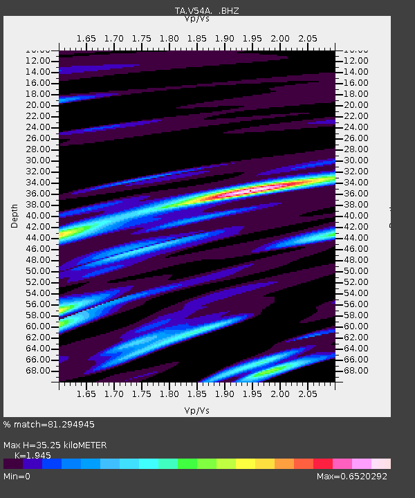
| Estimated Moho Depth: |
35.25 km |
| Estimated Crust Vp/Vs: |
1.95 |
| Assumed Crust Vp: |
6.419 km/s |
| Estimated Crust Vs: |
3.3 km/s |
| Estimated Crust Poisson's Ratio: |
0.32 |
|
| Radial Match: |
81.294945 % |
| Radial Bump: |
400 |
| Transverse Match: |
59.950798 % |
| Transverse Bump: |
390 |
| SOD ConfigId: |
494114 |
| Insert Time: |
2013-05-15 07:39:19.499 +0000 |
| GWidth: |
2.5 |
| Max Bumps: |
400 |
| Tol: |
0.001 |
|
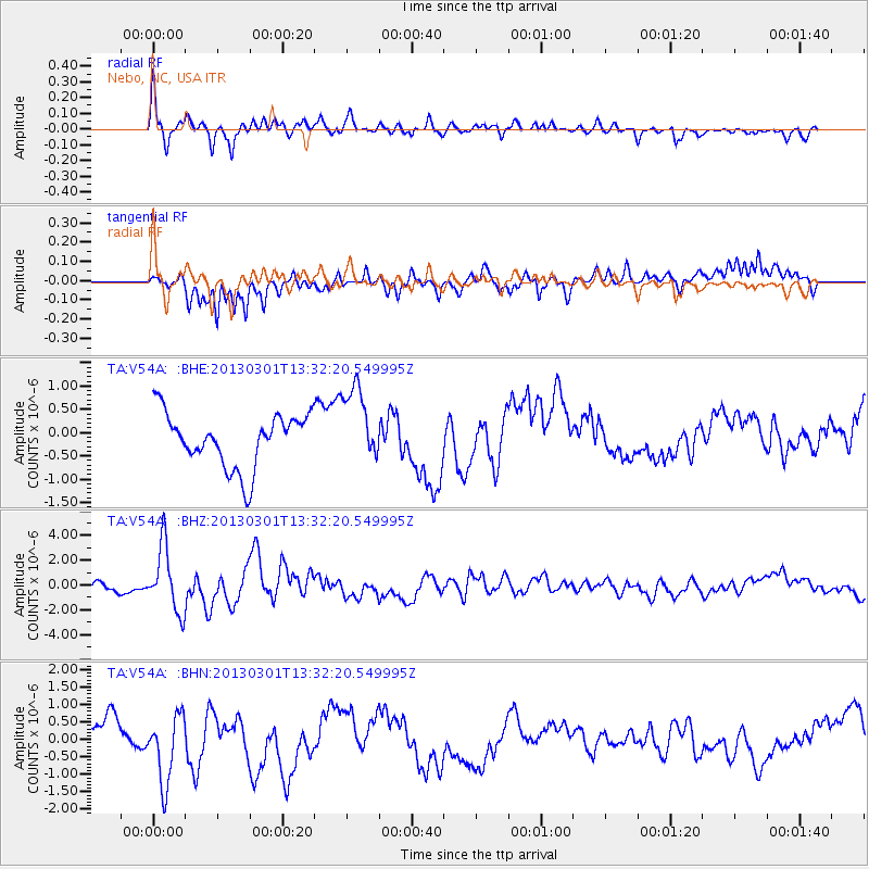
Signal To Noise
| Channel | StoN | STA | LTA |
| TA:V54A: :BHZ:20130301T13:32:20.549995Z | 5.58495 | 2.6194991E-6 | 4.690282E-7 |
| TA:V54A: :BHN:20130301T13:32:20.549995Z | 2.8045752 | 9.977717E-7 | 3.557657E-7 |
| TA:V54A: :BHE:20130301T13:32:20.549995Z | 1.4564924 | 8.35088E-7 | 5.733555E-7 |
| Arrivals |
| Ps | 5.3 SECOND |
| PpPs | 16 SECOND |
| PsPs/PpSs | 21 SECOND |


