You are here: Home > Network List > TA - USArray Transportable Network (new EarthScope stations) Stations List
> Station U55A TA2, Sparta, NC, USA > Earthquake Result Viewer
U55A TA2, Sparta, NC, USA - Earthquake Result Viewer
| Earthquake location: |
Kuril Islands |
| Earthquake latitude/longitude: |
51.0/157.4 |
| Earthquake time(UTC): |
2013/03/01 (060) 13:20:49 GMT |
| Earthquake Depth: |
29 km |
| Earthquake Magnitude: |
6.3 MB, 6.3 MS, 6.5 MW, 6.4 MW |
| Earthquake Catalog/Contributor: |
WHDF/NEIC |
|
| Network: |
TA USArray Transportable Network (new EarthScope stations) |
| Station: |
U55A TA2, Sparta, NC, USA |
| Lat/Lon: |
36.50 N/81.05 W |
| Elevation: |
863 m |
|
| Distance: |
78.9 deg |
| Az: |
44.404 deg |
| Baz: |
326.686 deg |
| Ray Param: |
0.049278222 |
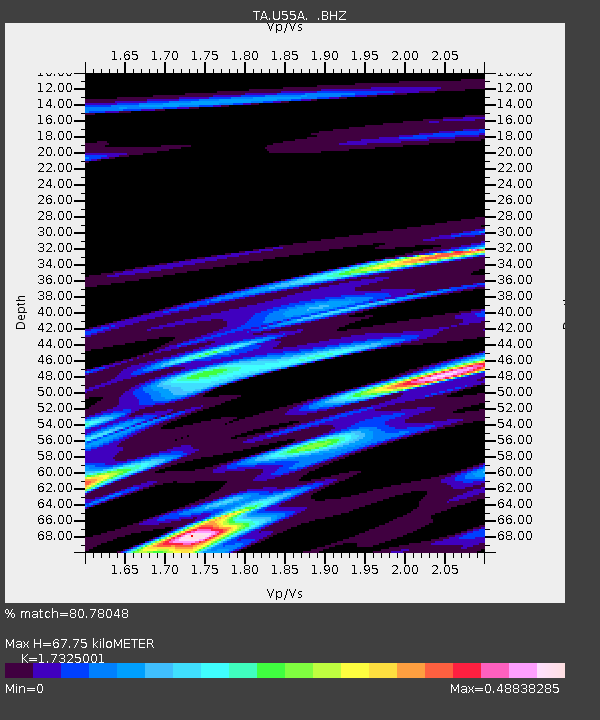
| Estimated Moho Depth: |
67.75 km |
| Estimated Crust Vp/Vs: |
1.73 |
| Assumed Crust Vp: |
6.159 km/s |
| Estimated Crust Vs: |
3.555 km/s |
| Estimated Crust Poisson's Ratio: |
0.25 |
|
| Radial Match: |
80.78048 % |
| Radial Bump: |
400 |
| Transverse Match: |
32.10989 % |
| Transverse Bump: |
400 |
| SOD ConfigId: |
494114 |
| Insert Time: |
2013-05-15 07:39:44.194 +0000 |
| GWidth: |
2.5 |
| Max Bumps: |
400 |
| Tol: |
0.001 |
|
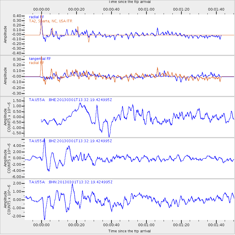
Signal To Noise
| Channel | StoN | STA | LTA |
| TA:U55A: :BHZ:20130301T13:32:19.424995Z | 8.401555 | 2.9665875E-6 | 3.530998E-7 |
| TA:U55A: :BHN:20130301T13:32:19.424995Z | 2.6982338 | 9.914227E-7 | 3.674339E-7 |
| TA:U55A: :BHE:20130301T13:32:19.424995Z | 1.4312822 | 8.3505324E-7 | 5.834302E-7 |
| Arrivals |
| Ps | 8.3 SECOND |
| PpPs | 29 SECOND |
| PsPs/PpSs | 38 SECOND |


