You are here: Home > Network List > CU - Caribbean Network (USGS) Stations List
> Station GRGR Grenville, Grenada > Earthquake Result Viewer
GRGR Grenville, Grenada - Earthquake Result Viewer
| Earthquake location: |
Near Coast Of Chiapas, Mexico |
| Earthquake latitude/longitude: |
14.7/-92.4 |
| Earthquake time(UTC): |
2014/07/07 (188) 11:23:55 GMT |
| Earthquake Depth: |
60 km |
| Earthquake Magnitude: |
6.9 MWW, 6.9 MWC, 7.1 MI |
| Earthquake Catalog/Contributor: |
NEIC PDE/NEIC COMCAT |
|
| Network: |
CU Caribbean Network (USGS) |
| Station: |
GRGR Grenville, Grenada |
| Lat/Lon: |
12.13 N/61.65 W |
| Elevation: |
195 m |
|
| Distance: |
30.0 deg |
| Az: |
91.2 deg |
| Baz: |
278.469 deg |
| Ray Param: |
0.07935979 |
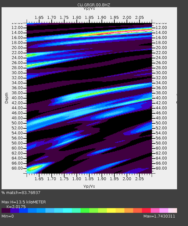
| Estimated Moho Depth: |
13.5 km |
| Estimated Crust Vp/Vs: |
2.02 |
| Assumed Crust Vp: |
5.738 km/s |
| Estimated Crust Vs: |
2.844 km/s |
| Estimated Crust Poisson's Ratio: |
0.34 |
|
| Radial Match: |
83.76937 % |
| Radial Bump: |
400 |
| Transverse Match: |
83.146996 % |
| Transverse Bump: |
400 |
| SOD ConfigId: |
3390531 |
| Insert Time: |
2019-04-12 17:52:58.872 +0000 |
| GWidth: |
2.5 |
| Max Bumps: |
400 |
| Tol: |
0.001 |
|

Signal To Noise
| Channel | StoN | STA | LTA |
| CU:GRGR:00:BHZ:20140707T11:29:28.772987Z | 8.5572195 | 7.1130744E-6 | 8.3123666E-7 |
| CU:GRGR:00:BH1:20140707T11:29:28.772987Z | 1.7312564 | 1.6613874E-6 | 9.596426E-7 |
| CU:GRGR:00:BH2:20140707T11:29:28.772987Z | 3.2101634 | 3.0616352E-6 | 9.53732E-7 |
| Arrivals |
| Ps | 2.5 SECOND |
| PpPs | 6.7 SECOND |
| PsPs/PpSs | 9.2 SECOND |


