You are here: Home > Network List > TA - USArray Transportable Network (new EarthScope stations) Stations List
> Station E55A Montcerf-Lytton, QC, CAN > Earthquake Result Viewer
E55A Montcerf-Lytton, QC, CAN - Earthquake Result Viewer

| Earthquake location: |
Near Coast Of Chiapas, Mexico |
| Earthquake latitude/longitude: |
14.7/-92.4 |
| Earthquake time(UTC): |
2014/07/07 (188) 11:23:55 GMT |
| Earthquake Depth: |
60 km |
| Earthquake Magnitude: |
6.9 MWW, 6.9 MWC, 7.1 MI |
| Earthquake Catalog/Contributor: |
NEIC PDE/NEIC COMCAT |
|
| Network: |
TA USArray Transportable Network (new EarthScope stations) |
| Station: |
E55A Montcerf-Lytton, QC, CAN |
| Lat/Lon: |
46.45 N/76.06 W |
| Elevation: |
180 m |
|
| Distance: |
34.5 deg |
| Az: |
20.121 deg |
| Baz: |
208.778 deg |
| Ray Param: |
0.07757201 |
| Estimated Moho Depth: |
38.75 km |
| Estimated Crust Vp/Vs: |
1.79 |
| Assumed Crust Vp: |
6.622 km/s |
| Estimated Crust Vs: |
3.7 km/s |
| Estimated Crust Poisson's Ratio: |
0.27 |
|
| Radial Match: |
94.15408 % |
| Radial Bump: |
331 |
| Transverse Match: |
74.01063 % |
| Transverse Bump: |
400 |
| SOD ConfigId: |
3390531 |
| Insert Time: |
2019-04-12 17:54:23.303 +0000 |
| GWidth: |
2.5 |
| Max Bumps: |
400 |
| Tol: |
0.001 |
|
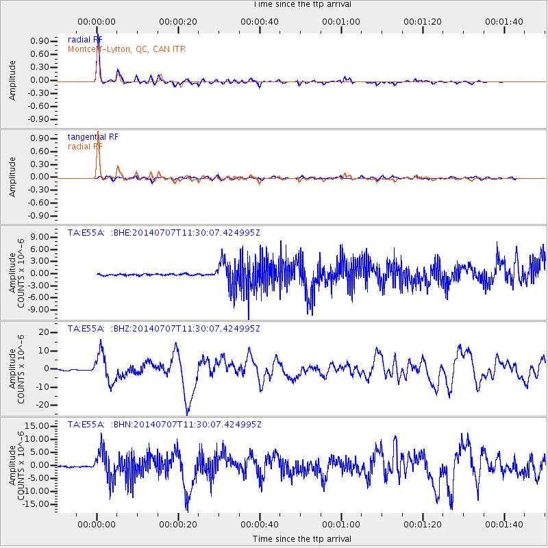
Signal To Noise
| Channel | StoN | STA | LTA |
| TA:E55A: :BHZ:20140707T11:30:07.424995Z | 39.004875 | 8.074915E-6 | 2.0702323E-7 |
| TA:E55A: :BHN:20140707T11:30:07.424995Z | 34.36267 | 5.556754E-6 | 1.6170902E-7 |
| TA:E55A: :BHE:20140707T11:30:07.424995Z | 20.56122 | 3.3170559E-6 | 1.6132583E-7 |
| Arrivals |
| Ps | 5.0 SECOND |
| PpPs | 15 SECOND |
| PsPs/PpSs | 20 SECOND |


