You are here: Home > Network List > TA - USArray Transportable Network (new EarthScope stations) Stations List
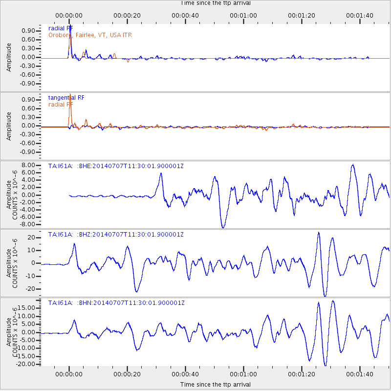
> Station I61A Oroboro, Fairlee, VT, USA > Earthquake Result Viewer
I61A Oroboro, Fairlee, VT, USA - Earthquake Result Viewer
| Earthquake location: |
Near Coast Of Chiapas, Mexico |
| Earthquake latitude/longitude: |
14.7/-92.4 |
| Earthquake time(UTC): |
2014/07/07 (188) 11:23:55 GMT |
| Earthquake Depth: |
60 km |
| Earthquake Magnitude: |
6.9 MWW, 6.9 MWC, 7.1 MI |
| Earthquake Catalog/Contributor: |
NEIC PDE/NEIC COMCAT |
|
| Network: |
TA USArray Transportable Network (new EarthScope stations) |
| Station: |
I61A Oroboro, Fairlee, VT, USA |
| Lat/Lon: |
43.93 N/72.21 W |
| Elevation: |
287 m |
|
| Distance: |
33.8 deg |
| Az: |
26.634 deg |
| Baz: |
216.893 deg |
| Ray Param: |
0.07789116 |
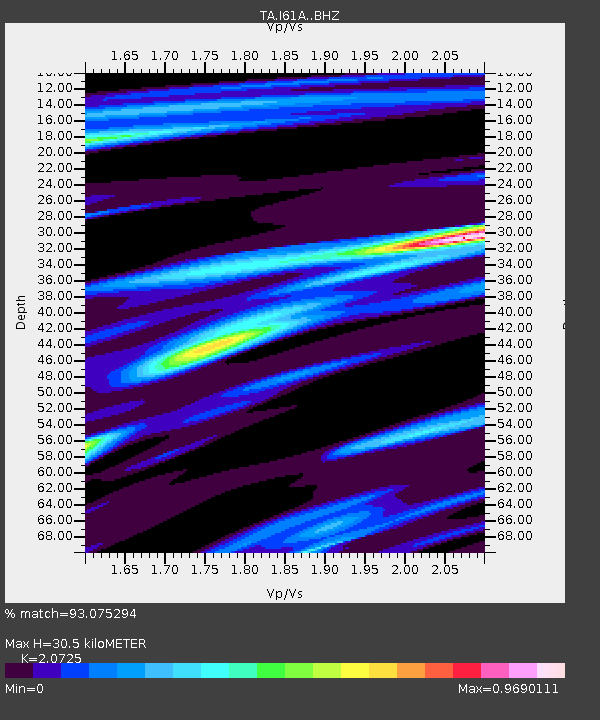
| Estimated Moho Depth: |
30.5 km |
| Estimated Crust Vp/Vs: |
2.07 |
| Assumed Crust Vp: |
6.419 km/s |
| Estimated Crust Vs: |
3.097 km/s |
| Estimated Crust Poisson's Ratio: |
0.35 |
|
| Radial Match: |
93.075294 % |
| Radial Bump: |
189 |
| Transverse Match: |
73.848564 % |
| Transverse Bump: |
400 |
| SOD ConfigId: |
3390531 |
| Insert Time: |
2019-04-12 17:54:29.991 +0000 |
| GWidth: |
2.5 |
| Max Bumps: |
400 |
| Tol: |
0.001 |
|
Signal To Noise
| Channel | StoN | STA | LTA |
| TA:I61A: :BHZ:20140707T11:30:01.900001Z | 29.673477 | 7.256204E-6 | 2.44535E-7 |
| TA:I61A: :BHN:20140707T11:30:01.900001Z | 25.088297 | 3.5984488E-6 | 1.4343138E-7 |
| TA:I61A: :BHE:20140707T11:30:01.900001Z | 18.821793 | 2.9094303E-6 | 1.5457775E-7 |
| Arrivals |
| Ps | 5.4 SECOND |
| PpPs | 14 SECOND |
| PsPs/PpSs | 19 SECOND |


