You are here: Home > Network List > TA - USArray Transportable Network (new EarthScope stations) Stations List
> Station L55A Hinsdale, NY, USA > Earthquake Result Viewer
L55A Hinsdale, NY, USA - Earthquake Result Viewer
| Earthquake location: |
Near Coast Of Chiapas, Mexico |
| Earthquake latitude/longitude: |
14.7/-92.4 |
| Earthquake time(UTC): |
2014/07/07 (188) 11:23:55 GMT |
| Earthquake Depth: |
60 km |
| Earthquake Magnitude: |
6.9 MWW, 6.9 MWC, 7.1 MI |
| Earthquake Catalog/Contributor: |
NEIC PDE/NEIC COMCAT |
|
| Network: |
TA USArray Transportable Network (new EarthScope stations) |
| Station: |
L55A Hinsdale, NY, USA |
| Lat/Lon: |
42.18 N/78.44 W |
| Elevation: |
633 m |
|
| Distance: |
29.9 deg |
| Az: |
21.107 deg |
| Baz: |
207.954 deg |
| Ray Param: |
0.07939225 |
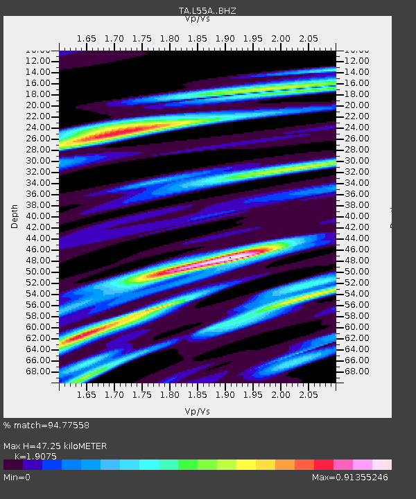
| Estimated Moho Depth: |
47.25 km |
| Estimated Crust Vp/Vs: |
1.91 |
| Assumed Crust Vp: |
6.419 km/s |
| Estimated Crust Vs: |
3.365 km/s |
| Estimated Crust Poisson's Ratio: |
0.31 |
|
| Radial Match: |
94.77558 % |
| Radial Bump: |
382 |
| Transverse Match: |
62.52821 % |
| Transverse Bump: |
400 |
| SOD ConfigId: |
3390531 |
| Insert Time: |
2019-04-12 17:54:34.589 +0000 |
| GWidth: |
2.5 |
| Max Bumps: |
400 |
| Tol: |
0.001 |
|
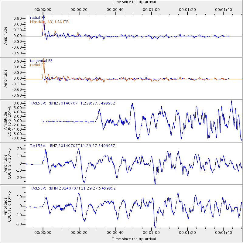
Signal To Noise
| Channel | StoN | STA | LTA |
| TA:L55A: :BHZ:20140707T11:29:27.549995Z | 39.006416 | 9.276229E-6 | 2.3781291E-7 |
| TA:L55A: :BHN:20140707T11:29:27.549995Z | 35.432144 | 5.553894E-6 | 1.5674733E-7 |
| TA:L55A: :BHE:20140707T11:29:27.549995Z | 20.621109 | 2.6799335E-6 | 1.2996068E-7 |
| Arrivals |
| Ps | 7.2 SECOND |
| PpPs | 20 SECOND |
| PsPs/PpSs | 27 SECOND |


