You are here: Home > Network List > TO - Tectonic Observatory Stations List
> Station CC31 CCSE CC31 > Earthquake Result Viewer
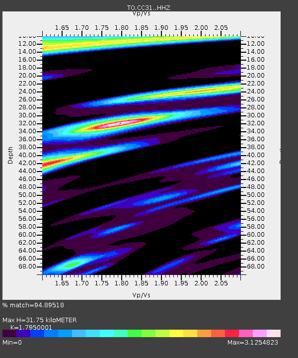
CC31 CCSE CC31 - Earthquake Result Viewer
| Earthquake location: |
Near Coast Of Chiapas, Mexico |
| Earthquake latitude/longitude: |
14.7/-92.4 |
| Earthquake time(UTC): |
2014/07/07 (188) 11:23:55 GMT |
| Earthquake Depth: |
60 km |
| Earthquake Magnitude: |
6.9 MWW, 6.9 MWC, 7.1 MI |
| Earthquake Catalog/Contributor: |
NEIC PDE/NEIC COMCAT |
|
| Network: |
TO Tectonic Observatory |
| Station: |
CC31 CCSE CC31 |
| Lat/Lon: |
36.32 N/119.27 W |
| Elevation: |
93 m |
|
| Distance: |
32.2 deg |
| Az: |
316.777 deg |
| Baz: |
124.876 deg |
| Ray Param: |
0.0786179 |
| Estimated Moho Depth: |
31.75 km |
| Estimated Crust Vp/Vs: |
1.80 |
| Assumed Crust Vp: |
6.291 km/s |
| Estimated Crust Vs: |
3.505 km/s |
| Estimated Crust Poisson's Ratio: |
0.27 |
|
| Radial Match: |
94.89518 % |
| Radial Bump: |
303 |
| Transverse Match: |
88.74292 % |
| Transverse Bump: |
400 |
| SOD ConfigId: |
3390531 |
| Insert Time: |
2019-04-12 17:55:01.106 +0000 |
| GWidth: |
2.5 |
| Max Bumps: |
400 |
| Tol: |
0.001 |
|

Signal To Noise
| Channel | StoN | STA | LTA |
| TO:CC31: :HHZ:20140707T11:29:47.359993Z | 19.410446 | 8.796172E-6 | 4.531669E-7 |
| TO:CC31: :HHN:20140707T11:29:47.359993Z | 8.635102 | 4.011672E-6 | 4.6457725E-7 |
| TO:CC31: :HHE:20140707T11:29:47.359993Z | 6.44147 | 3.4520306E-6 | 5.3590725E-7 |
| Arrivals |
| Ps | 4.3 SECOND |
| PpPs | 13 SECOND |
| PsPs/PpSs | 17 SECOND |


