You are here: Home > Network List > X812 - Deep Structure of Three Continental Sutures in Eastern North America Stations List
> Station QM12 Camp Vic, Maine, USA > Earthquake Result Viewer
QM12 Camp Vic, Maine, USA - Earthquake Result Viewer
| Earthquake location: |
Near Coast Of Chiapas, Mexico |
| Earthquake latitude/longitude: |
14.7/-92.4 |
| Earthquake time(UTC): |
2014/07/07 (188) 11:23:55 GMT |
| Earthquake Depth: |
60 km |
| Earthquake Magnitude: |
6.9 MWW, 6.9 MWC, 7.1 MI |
| Earthquake Catalog/Contributor: |
NEIC PDE/NEIC COMCAT |
|
| Network: |
X8 Deep Structure of Three Continental Sutures in Eastern North America |
| Station: |
QM12 Camp Vic, Maine, USA |
| Lat/Lon: |
44.97 N/67.86 W |
| Elevation: |
15 m |
|
| Distance: |
36.6 deg |
| Az: |
29.64 deg |
| Baz: |
222.383 deg |
| Ray Param: |
0.0764278 |
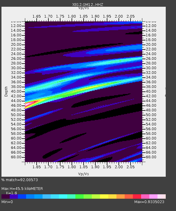
| Estimated Moho Depth: |
45.5 km |
| Estimated Crust Vp/Vs: |
1.60 |
| Assumed Crust Vp: |
6.419 km/s |
| Estimated Crust Vs: |
4.012 km/s |
| Estimated Crust Poisson's Ratio: |
0.18 |
|
| Radial Match: |
92.08573 % |
| Radial Bump: |
181 |
| Transverse Match: |
66.00551 % |
| Transverse Bump: |
400 |
| SOD ConfigId: |
3390531 |
| Insert Time: |
2019-04-12 17:55:29.415 +0000 |
| GWidth: |
2.5 |
| Max Bumps: |
400 |
| Tol: |
0.001 |
|

Signal To Noise
| Channel | StoN | STA | LTA |
| X8:QM12: :HHZ:20140707T11:30:25.799995Z | 36.915867 | 9.643155E-6 | 2.612198E-7 |
| X8:QM12: :HHN:20140707T11:30:25.799995Z | 10.4441 | 3.7123673E-6 | 3.5545114E-7 |
| X8:QM12: :HHE:20140707T11:30:25.799995Z | 1.737458 | 5.6545023E-6 | 3.2544685E-6 |
| Arrivals |
| Ps | 4.6 SECOND |
| PpPs | 17 SECOND |
| PsPs/PpSs | 22 SECOND |


