You are here: Home > Network List > X812 - Deep Structure of Three Continental Sutures in Eastern North America Stations List
> Station QM15 Land Trust South, Maine, USA > Earthquake Result Viewer
QM15 Land Trust South, Maine, USA - Earthquake Result Viewer
| Earthquake location: |
Near Coast Of Chiapas, Mexico |
| Earthquake latitude/longitude: |
14.7/-92.4 |
| Earthquake time(UTC): |
2014/07/07 (188) 11:23:55 GMT |
| Earthquake Depth: |
60 km |
| Earthquake Magnitude: |
6.9 MWW, 6.9 MWC, 7.1 MI |
| Earthquake Catalog/Contributor: |
NEIC PDE/NEIC COMCAT |
|
| Network: |
X8 Deep Structure of Three Continental Sutures in Eastern North America |
| Station: |
QM15 Land Trust South, Maine, USA |
| Lat/Lon: |
45.09 N/67.84 W |
| Elevation: |
151 m |
|
| Distance: |
36.7 deg |
| Az: |
29.523 deg |
| Baz: |
222.306 deg |
| Ray Param: |
0.076372944 |
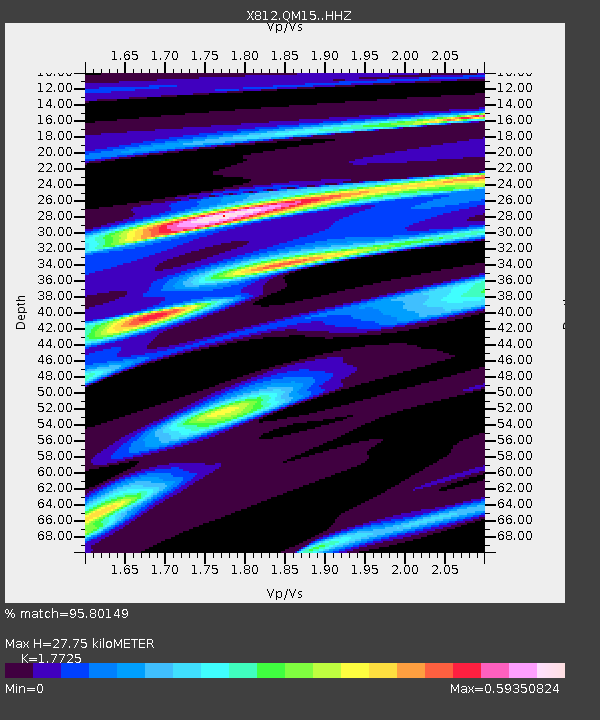
| Estimated Moho Depth: |
27.75 km |
| Estimated Crust Vp/Vs: |
1.77 |
| Assumed Crust Vp: |
6.419 km/s |
| Estimated Crust Vs: |
3.622 km/s |
| Estimated Crust Poisson's Ratio: |
0.27 |
|
| Radial Match: |
95.80149 % |
| Radial Bump: |
148 |
| Transverse Match: |
93.946915 % |
| Transverse Bump: |
400 |
| SOD ConfigId: |
3390531 |
| Insert Time: |
2019-04-12 17:55:29.240 +0000 |
| GWidth: |
2.5 |
| Max Bumps: |
400 |
| Tol: |
0.001 |
|

Signal To Noise
| Channel | StoN | STA | LTA |
| X8:QM15: :HHZ:20140707T11:30:26.660011Z | 28.81476 | 8.868243E-6 | 3.0776735E-7 |
| X8:QM15: :HHN:20140707T11:30:26.660011Z | 16.186657 | 3.3443416E-6 | 2.06611E-7 |
| X8:QM15: :HHE:20140707T11:30:26.660011Z | 25.55082 | 4.643514E-6 | 1.817364E-7 |
| Arrivals |
| Ps | 3.6 SECOND |
| PpPs | 11 SECOND |
| PsPs/PpSs | 15 SECOND |


