You are here: Home > Network List > X812 - Deep Structure of Three Continental Sutures in Eastern North America Stations List
> Station QM58 Lac a Jim, Quebec, Canada > Earthquake Result Viewer
QM58 Lac a Jim, Quebec, Canada - Earthquake Result Viewer
| Earthquake location: |
Near Coast Of Chiapas, Mexico |
| Earthquake latitude/longitude: |
14.7/-92.4 |
| Earthquake time(UTC): |
2014/07/07 (188) 11:23:55 GMT |
| Earthquake Depth: |
60 km |
| Earthquake Magnitude: |
6.9 MWW, 6.9 MWC, 7.1 MI |
| Earthquake Catalog/Contributor: |
NEIC PDE/NEIC COMCAT |
|
| Network: |
X8 Deep Structure of Three Continental Sutures in Eastern North America |
| Station: |
QM58 Lac a Jim, Quebec, Canada |
| Lat/Lon: |
49.05 N/72.74 W |
| Elevation: |
190 m |
|
| Distance: |
37.8 deg |
| Az: |
21.165 deg |
| Baz: |
212.069 deg |
| Ray Param: |
0.07574164 |
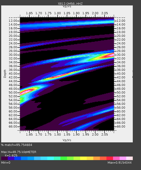
| Estimated Moho Depth: |
49.75 km |
| Estimated Crust Vp/Vs: |
1.62 |
| Assumed Crust Vp: |
6.61 km/s |
| Estimated Crust Vs: |
4.068 km/s |
| Estimated Crust Poisson's Ratio: |
0.20 |
|
| Radial Match: |
95.754684 % |
| Radial Bump: |
142 |
| Transverse Match: |
79.723076 % |
| Transverse Bump: |
400 |
| SOD ConfigId: |
3390531 |
| Insert Time: |
2019-04-12 17:55:36.167 +0000 |
| GWidth: |
2.5 |
| Max Bumps: |
400 |
| Tol: |
0.001 |
|

Signal To Noise
| Channel | StoN | STA | LTA |
| X8:QM58: :HHZ:20140707T11:30:36.139991Z | 37.435966 | 7.802406E-6 | 2.0842003E-7 |
| X8:QM58: :HHN:20140707T11:30:36.139991Z | 22.410406 | 4.2713878E-6 | 1.9059841E-7 |
| X8:QM58: :HHE:20140707T11:30:36.139991Z | 18.80904 | 2.3595017E-6 | 1.2544508E-7 |
| Arrivals |
| Ps | 5.1 SECOND |
| PpPs | 18 SECOND |
| PsPs/PpSs | 23 SECOND |


