You are here: Home > Network List > XD14 - Illuminating the architecture of the greater Mount St. Helens magmatic systems f Stations List
> Station MF05 "Mount St Helens, WA" > Earthquake Result Viewer
MF05 "Mount St Helens, WA" - Earthquake Result Viewer
| Earthquake location: |
Near Coast Of Chiapas, Mexico |
| Earthquake latitude/longitude: |
14.7/-92.4 |
| Earthquake time(UTC): |
2014/07/07 (188) 11:23:55 GMT |
| Earthquake Depth: |
60 km |
| Earthquake Magnitude: |
6.9 MWW, 6.9 MWC, 7.1 MI |
| Earthquake Catalog/Contributor: |
NEIC PDE/NEIC COMCAT |
|
| Network: |
XD Illuminating the architecture of the greater Mount St. Helens magmatic systems f |
| Station: |
MF05 "Mount St Helens, WA" |
| Lat/Lon: |
46.39 N/122.39 W |
| Elevation: |
727 m |
|
| Distance: |
40.3 deg |
| Az: |
327.68 deg |
| Baz: |
131.642 deg |
| Ray Param: |
0.07430906 |
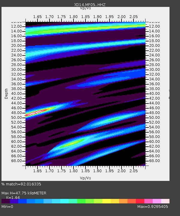
| Estimated Moho Depth: |
47.75 km |
| Estimated Crust Vp/Vs: |
1.64 |
| Assumed Crust Vp: |
6.566 km/s |
| Estimated Crust Vs: |
4.004 km/s |
| Estimated Crust Poisson's Ratio: |
0.20 |
|
| Radial Match: |
92.016335 % |
| Radial Bump: |
400 |
| Transverse Match: |
81.420334 % |
| Transverse Bump: |
400 |
| SOD ConfigId: |
3390531 |
| Insert Time: |
2019-04-12 17:55:56.391 +0000 |
| GWidth: |
2.5 |
| Max Bumps: |
400 |
| Tol: |
0.001 |
|

Signal To Noise
| Channel | StoN | STA | LTA |
| XD:MF05: :HHZ:20140707T11:30:56.405006Z | 36.672085 | 2.3221917E-6 | 6.332315E-8 |
| XD:MF05: :HHN:20140707T11:30:56.405006Z | 15.835636 | 9.2751173E-7 | 5.857117E-8 |
| XD:MF05: :HHE:20140707T11:30:56.405006Z | 13.478906 | 8.2169265E-7 | 6.0961376E-8 |
| Arrivals |
| Ps | 5.0 SECOND |
| PpPs | 18 SECOND |
| PsPs/PpSs | 23 SECOND |


