You are here: Home > Network List > XD14 - Illuminating the architecture of the greater Mount St. Helens magmatic systems f Stations List
> Station MF09 "Mount St Helens, WA" > Earthquake Result Viewer
MF09 "Mount St Helens, WA" - Earthquake Result Viewer
| Earthquake location: |
Near Coast Of Chiapas, Mexico |
| Earthquake latitude/longitude: |
14.7/-92.4 |
| Earthquake time(UTC): |
2014/07/07 (188) 11:23:55 GMT |
| Earthquake Depth: |
60 km |
| Earthquake Magnitude: |
6.9 MWW, 6.9 MWC, 7.1 MI |
| Earthquake Catalog/Contributor: |
NEIC PDE/NEIC COMCAT |
|
| Network: |
XD Illuminating the architecture of the greater Mount St. Helens magmatic systems f |
| Station: |
MF09 "Mount St Helens, WA" |
| Lat/Lon: |
46.39 N/121.86 W |
| Elevation: |
1216 m |
|
| Distance: |
40.0 deg |
| Az: |
328.057 deg |
| Baz: |
132.309 deg |
| Ray Param: |
0.07446256 |
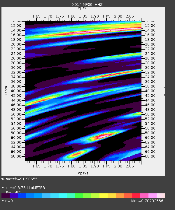
| Estimated Moho Depth: |
13.75 km |
| Estimated Crust Vp/Vs: |
1.97 |
| Assumed Crust Vp: |
6.597 km/s |
| Estimated Crust Vs: |
3.358 km/s |
| Estimated Crust Poisson's Ratio: |
0.33 |
|
| Radial Match: |
91.90655 % |
| Radial Bump: |
400 |
| Transverse Match: |
68.97946 % |
| Transverse Bump: |
400 |
| SOD ConfigId: |
3390531 |
| Insert Time: |
2019-04-12 17:55:57.470 +0000 |
| GWidth: |
2.5 |
| Max Bumps: |
400 |
| Tol: |
0.001 |
|

Signal To Noise
| Channel | StoN | STA | LTA |
| XD:MF09: :HHZ:20140707T11:30:54.164985Z | 38.643543 | 2.8587976E-6 | 7.397867E-8 |
| XD:MF09: :HHN:20140707T11:30:54.164985Z | 16.795769 | 1.1311176E-6 | 6.73454E-8 |
| XD:MF09: :HHE:20140707T11:30:54.164985Z | 8.742992 | 9.3371375E-7 | 1.06795675E-7 |
| Arrivals |
| Ps | 2.1 SECOND |
| PpPs | 5.8 SECOND |
| PsPs/PpSs | 7.9 SECOND |


