You are here: Home > Network List > XD14 - Illuminating the architecture of the greater Mount St. Helens magmatic systems f Stations List
> Station MH04 "Mount St Helens, WA" > Earthquake Result Viewer
MH04 "Mount St Helens, WA" - Earthquake Result Viewer
| Earthquake location: |
Near Coast Of Chiapas, Mexico |
| Earthquake latitude/longitude: |
14.7/-92.4 |
| Earthquake time(UTC): |
2014/07/07 (188) 11:23:55 GMT |
| Earthquake Depth: |
60 km |
| Earthquake Magnitude: |
6.9 MWW, 6.9 MWC, 7.1 MI |
| Earthquake Catalog/Contributor: |
NEIC PDE/NEIC COMCAT |
|
| Network: |
XD Illuminating the architecture of the greater Mount St. Helens magmatic systems f |
| Station: |
MH04 "Mount St Helens, WA" |
| Lat/Lon: |
46.28 N/122.43 W |
| Elevation: |
920 m |
|
| Distance: |
40.3 deg |
| Az: |
327.523 deg |
| Baz: |
131.493 deg |
| Ray Param: |
0.0743401 |
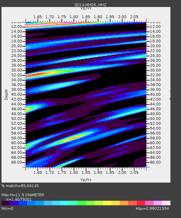
| Estimated Moho Depth: |
11.5 km |
| Estimated Crust Vp/Vs: |
1.61 |
| Assumed Crust Vp: |
6.566 km/s |
| Estimated Crust Vs: |
4.085 km/s |
| Estimated Crust Poisson's Ratio: |
0.18 |
|
| Radial Match: |
95.84145 % |
| Radial Bump: |
348 |
| Transverse Match: |
83.60373 % |
| Transverse Bump: |
400 |
| SOD ConfigId: |
3390531 |
| Insert Time: |
2019-04-12 17:56:04.200 +0000 |
| GWidth: |
2.5 |
| Max Bumps: |
400 |
| Tol: |
0.001 |
|

Signal To Noise
| Channel | StoN | STA | LTA |
| XD:MH04: :HHZ:20140707T11:30:55.965004Z | 41.046574 | 2.7746746E-6 | 6.759821E-8 |
| XD:MH04: :HHN:20140707T11:30:55.965004Z | 14.639386 | 1.1827434E-6 | 8.079187E-8 |
| XD:MH04: :HHE:20140707T11:30:55.965004Z | 14.90761 | 1.0875489E-6 | 7.2952595E-8 |
| Arrivals |
| Ps | 1.2 SECOND |
| PpPs | 4.2 SECOND |
| PsPs/PpSs | 5.4 SECOND |


