You are here: Home > Network List > XD14 - Illuminating the architecture of the greater Mount St. Helens magmatic systems f Stations List
> Station MI02 "Mount St Helens, WA" > Earthquake Result Viewer
MI02 "Mount St Helens, WA" - Earthquake Result Viewer
| Earthquake location: |
Near Coast Of Chiapas, Mexico |
| Earthquake latitude/longitude: |
14.7/-92.4 |
| Earthquake time(UTC): |
2014/07/07 (188) 11:23:55 GMT |
| Earthquake Depth: |
60 km |
| Earthquake Magnitude: |
6.9 MWW, 6.9 MWC, 7.1 MI |
| Earthquake Catalog/Contributor: |
NEIC PDE/NEIC COMCAT |
|
| Network: |
XD Illuminating the architecture of the greater Mount St. Helens magmatic systems f |
| Station: |
MI02 "Mount St Helens, WA" |
| Lat/Lon: |
46.22 N/122.67 W |
| Elevation: |
349 m |
|
| Distance: |
40.3 deg |
| Az: |
327.281 deg |
| Baz: |
131.136 deg |
| Ray Param: |
0.07429137 |
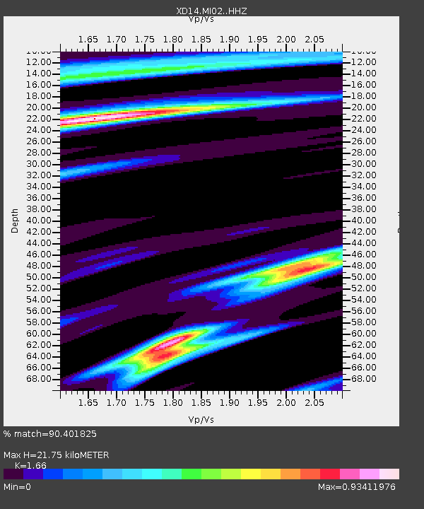
| Estimated Moho Depth: |
21.75 km |
| Estimated Crust Vp/Vs: |
1.66 |
| Assumed Crust Vp: |
6.566 km/s |
| Estimated Crust Vs: |
3.956 km/s |
| Estimated Crust Poisson's Ratio: |
0.22 |
|
| Radial Match: |
90.401825 % |
| Radial Bump: |
308 |
| Transverse Match: |
78.74035 % |
| Transverse Bump: |
400 |
| SOD ConfigId: |
3390531 |
| Insert Time: |
2019-04-12 17:56:06.913 +0000 |
| GWidth: |
2.5 |
| Max Bumps: |
400 |
| Tol: |
0.001 |
|

Signal To Noise
| Channel | StoN | STA | LTA |
| XD:MI02: :HHZ:20140707T11:30:56.650001Z | 37.970272 | 2.829594E-6 | 7.45213E-8 |
| XD:MI02: :HHN:20140707T11:30:56.650001Z | 8.919174 | 1.1322271E-6 | 1.2694305E-7 |
| XD:MI02: :HHE:20140707T11:30:56.650001Z | 8.4437 | 8.2474236E-7 | 9.767547E-8 |
| Arrivals |
| Ps | 2.4 SECOND |
| PpPs | 8.1 SECOND |
| PsPs/PpSs | 11 SECOND |


