You are here: Home > Network List > XD14 - Illuminating the architecture of the greater Mount St. Helens magmatic systems f Stations List
> Station MJ02 "Mount St Helens, WA" > Earthquake Result Viewer
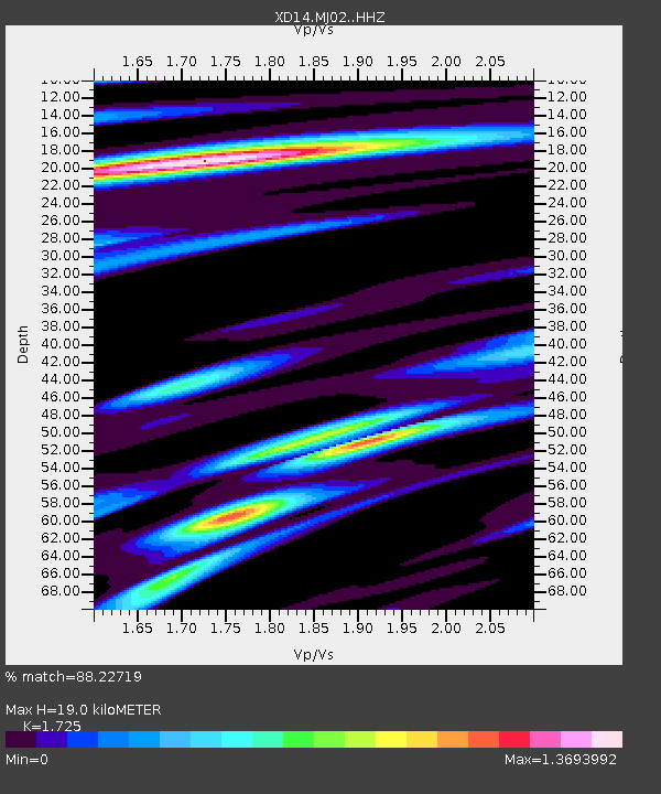
MJ02 "Mount St Helens, WA" - Earthquake Result Viewer
| Earthquake location: |
Near Coast Of Chiapas, Mexico |
| Earthquake latitude/longitude: |
14.7/-92.4 |
| Earthquake time(UTC): |
2014/07/07 (188) 11:23:55 GMT |
| Earthquake Depth: |
60 km |
| Earthquake Magnitude: |
6.9 MWW, 6.9 MWC, 7.1 MI |
| Earthquake Catalog/Contributor: |
NEIC PDE/NEIC COMCAT |
|
| Network: |
XD Illuminating the architecture of the greater Mount St. Helens magmatic systems f |
| Station: |
MJ02 "Mount St Helens, WA" |
| Lat/Lon: |
46.14 N/122.70 W |
| Elevation: |
317 m |
|
| Distance: |
40.3 deg |
| Az: |
327.166 deg |
| Baz: |
131.023 deg |
| Ray Param: |
0.074310474 |
| Estimated Moho Depth: |
19.0 km |
| Estimated Crust Vp/Vs: |
1.73 |
| Assumed Crust Vp: |
6.566 km/s |
| Estimated Crust Vs: |
3.806 km/s |
| Estimated Crust Poisson's Ratio: |
0.25 |
|
| Radial Match: |
88.22719 % |
| Radial Bump: |
296 |
| Transverse Match: |
76.22093 % |
| Transverse Bump: |
400 |
| SOD ConfigId: |
3390531 |
| Insert Time: |
2019-04-12 17:56:11.105 +0000 |
| GWidth: |
2.5 |
| Max Bumps: |
400 |
| Tol: |
0.001 |
|

Signal To Noise
| Channel | StoN | STA | LTA |
| XD:MJ02: :HHZ:20140707T11:30:56.380012Z | 35.68767 | 2.4850387E-6 | 6.9632975E-8 |
| XD:MJ02: :HHN:20140707T11:30:56.380012Z | 7.048209 | 1.0181801E-6 | 1.444594E-7 |
| XD:MJ02: :HHE:20140707T11:30:56.380012Z | 7.913614 | 1.0554268E-6 | 1.333685E-7 |
| Arrivals |
| Ps | 2.3 SECOND |
| PpPs | 7.3 SECOND |
| PsPs/PpSs | 9.6 SECOND |


