You are here: Home > Network List > XD14 - Illuminating the architecture of the greater Mount St. Helens magmatic systems f Stations List
> Station MP08 "Mount St Helens, WA" > Earthquake Result Viewer
MP08 "Mount St Helens, WA" - Earthquake Result Viewer
| Earthquake location: |
Near Coast Of Chiapas, Mexico |
| Earthquake latitude/longitude: |
14.7/-92.4 |
| Earthquake time(UTC): |
2014/07/07 (188) 11:23:55 GMT |
| Earthquake Depth: |
60 km |
| Earthquake Magnitude: |
6.9 MWW, 6.9 MWC, 7.1 MI |
| Earthquake Catalog/Contributor: |
NEIC PDE/NEIC COMCAT |
|
| Network: |
XD Illuminating the architecture of the greater Mount St. Helens magmatic systems f |
| Station: |
MP08 "Mount St Helens, WA" |
| Lat/Lon: |
45.87 N/121.91 W |
| Elevation: |
781 m |
|
| Distance: |
39.7 deg |
| Az: |
327.414 deg |
| Baz: |
131.779 deg |
| Ray Param: |
0.07464868 |
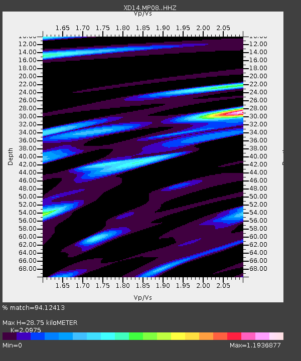
| Estimated Moho Depth: |
28.75 km |
| Estimated Crust Vp/Vs: |
2.10 |
| Assumed Crust Vp: |
6.597 km/s |
| Estimated Crust Vs: |
3.145 km/s |
| Estimated Crust Poisson's Ratio: |
0.35 |
|
| Radial Match: |
94.12413 % |
| Radial Bump: |
340 |
| Transverse Match: |
84.781586 % |
| Transverse Bump: |
400 |
| SOD ConfigId: |
3390531 |
| Insert Time: |
2019-04-12 17:56:29.705 +0000 |
| GWidth: |
2.5 |
| Max Bumps: |
400 |
| Tol: |
0.001 |
|

Signal To Noise
| Channel | StoN | STA | LTA |
| XD:MP08: :HHZ:20140707T11:30:51.475013Z | 31.277897 | 3.7665416E-6 | 1.2042183E-7 |
| XD:MP08: :HHN:20140707T11:30:51.475013Z | 11.50864 | 1.5018898E-6 | 1.3050106E-7 |
| XD:MP08: :HHE:20140707T11:30:51.475013Z | 7.7553797 | 2.0107793E-6 | 2.5927542E-7 |
| Arrivals |
| Ps | 5.1 SECOND |
| PpPs | 13 SECOND |
| PsPs/PpSs | 18 SECOND |


