You are here: Home > Network List > TA - USArray Transportable Network (new EarthScope stations) Stations List
> Station J04D Umpqua National Forest, Toketee, OR, USA > Earthquake Result Viewer
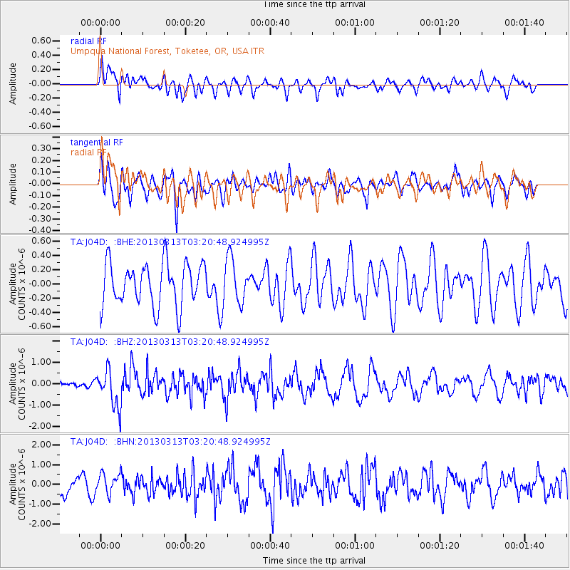
J04D Umpqua National Forest, Toketee, OR, USA - Earthquake Result Viewer
*The percent match for this event was below the threshold and hence no stack was calculated.
| Earthquake location: |
Eastern Siberia, Russia |
| Earthquake latitude/longitude: |
60.2/163.4 |
| Earthquake time(UTC): |
2013/03/13 (072) 03:12:52 GMT |
| Earthquake Depth: |
5.0 km |
| Earthquake Magnitude: |
5.7 MB, 5.6 MS, 5.8 MW, 5.8 MW |
| Earthquake Catalog/Contributor: |
WHDF/NEIC |
|
| Network: |
TA USArray Transportable Network (new EarthScope stations) |
| Station: |
J04D Umpqua National Forest, Toketee, OR, USA |
| Lat/Lon: |
43.24 N/122.11 W |
| Elevation: |
1948 m |
|
| Distance: |
46.4 deg |
| Az: |
76.329 deg |
| Baz: |
318.435 deg |
| Ray Param: |
$rayparam |
*The percent match for this event was below the threshold and hence was not used in the summary stack. |
|
| Radial Match: |
60.376522 % |
| Radial Bump: |
400 |
| Transverse Match: |
55.947884 % |
| Transverse Bump: |
400 |
| SOD ConfigId: |
506122 |
| Insert Time: |
2013-05-26 03:29:29.296 +0000 |
| GWidth: |
2.5 |
| Max Bumps: |
400 |
| Tol: |
0.001 |
|
Signal To Noise
| Channel | StoN | STA | LTA |
| TA:J04D: :BHZ:20130313T03:20:48.924995Z | 5.545481 | 8.9562894E-7 | 1.615061E-7 |
| TA:J04D: :BHN:20130313T03:20:48.924995Z | 1.2324641 | 5.2479203E-7 | 4.2580712E-7 |
| TA:J04D: :BHE:20130313T03:20:48.924995Z | 1.0287147 | 3.1022375E-7 | 3.0156446E-7 |
| Arrivals |
| Ps | |
| PpPs | |
| PsPs/PpSs | |


