You are here: Home > Network List > TA - USArray Transportable Network (new EarthScope stations) Stations List
> Station Z41A Richland Creek Farm, El Dorado, AR, USA > Earthquake Result Viewer
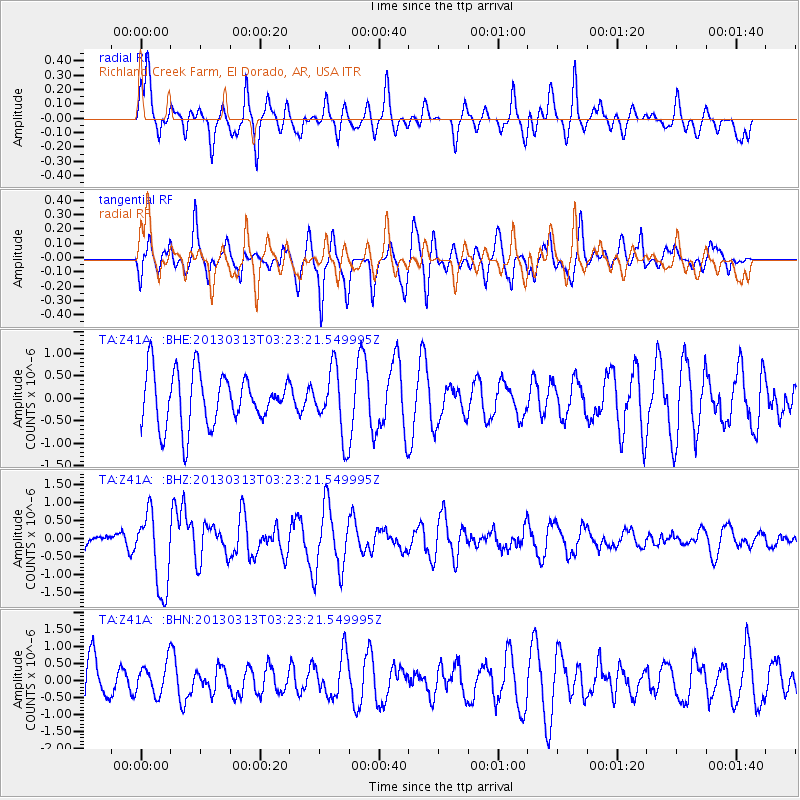
Z41A Richland Creek Farm, El Dorado, AR, USA - Earthquake Result Viewer
*The percent match for this event was below the threshold and hence no stack was calculated.
| Earthquake location: |
Eastern Siberia, Russia |
| Earthquake latitude/longitude: |
60.2/163.4 |
| Earthquake time(UTC): |
2013/03/13 (072) 03:12:52 GMT |
| Earthquake Depth: |
5.0 km |
| Earthquake Magnitude: |
5.7 MB, 5.6 MS, 5.8 MW, 5.8 MW |
| Earthquake Catalog/Contributor: |
WHDF/NEIC |
|
| Network: |
TA USArray Transportable Network (new EarthScope stations) |
| Station: |
Z41A Richland Creek Farm, El Dorado, AR, USA |
| Lat/Lon: |
33.26 N/92.80 W |
| Elevation: |
62 m |
|
| Distance: |
68.1 deg |
| Az: |
61.298 deg |
| Baz: |
328.51 deg |
| Ray Param: |
$rayparam |
*The percent match for this event was below the threshold and hence was not used in the summary stack. |
|
| Radial Match: |
63.348167 % |
| Radial Bump: |
400 |
| Transverse Match: |
52.828247 % |
| Transverse Bump: |
400 |
| SOD ConfigId: |
506122 |
| Insert Time: |
2013-05-26 03:31:26.037 +0000 |
| GWidth: |
2.5 |
| Max Bumps: |
400 |
| Tol: |
0.001 |
|
Signal To Noise
| Channel | StoN | STA | LTA |
| TA:Z41A: :BHZ:20130313T03:23:21.549995Z | 5.220598 | 1.0823519E-6 | 2.0732334E-7 |
| TA:Z41A: :BHN:20130313T03:23:21.549995Z | 0.7648666 | 4.5768905E-7 | 5.9839067E-7 |
| TA:Z41A: :BHE:20130313T03:23:21.549995Z | 1.2577134 | 7.383942E-7 | 5.8709253E-7 |
| Arrivals |
| Ps | |
| PpPs | |
| PsPs/PpSs | |


