You are here: Home > Network List > TA - USArray Transportable Network (new EarthScope stations) Stations List
> Station V50A Pikevile, TN, USA > Earthquake Result Viewer
V50A Pikevile, TN, USA - Earthquake Result Viewer
| Earthquake location: |
Eastern Siberia, Russia |
| Earthquake latitude/longitude: |
60.2/163.4 |
| Earthquake time(UTC): |
2013/03/13 (072) 03:12:52 GMT |
| Earthquake Depth: |
5.0 km |
| Earthquake Magnitude: |
5.7 MB, 5.6 MS, 5.8 MW, 5.8 MW |
| Earthquake Catalog/Contributor: |
WHDF/NEIC |
|
| Network: |
TA USArray Transportable Network (new EarthScope stations) |
| Station: |
V50A Pikevile, TN, USA |
| Lat/Lon: |
35.67 N/85.10 W |
| Elevation: |
287 m |
|
| Distance: |
69.3 deg |
| Az: |
54.105 deg |
| Baz: |
330.234 deg |
| Ray Param: |
0.055778798 |
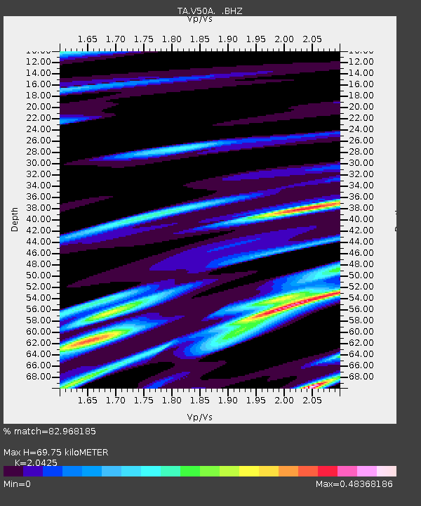
| Estimated Moho Depth: |
69.75 km |
| Estimated Crust Vp/Vs: |
2.04 |
| Assumed Crust Vp: |
6.35 km/s |
| Estimated Crust Vs: |
3.109 km/s |
| Estimated Crust Poisson's Ratio: |
0.34 |
|
| Radial Match: |
82.968185 % |
| Radial Bump: |
400 |
| Transverse Match: |
73.02891 % |
| Transverse Bump: |
400 |
| SOD ConfigId: |
506122 |
| Insert Time: |
2013-05-26 03:39:49.679 +0000 |
| GWidth: |
2.5 |
| Max Bumps: |
400 |
| Tol: |
0.001 |
|

Signal To Noise
| Channel | StoN | STA | LTA |
| TA:V50A: :BHZ:20130313T03:23:28.849983Z | 2.284266 | 1.184774E-6 | 5.186672E-7 |
| TA:V50A: :BHN:20130313T03:23:28.849983Z | 2.7149546 | 4.9094473E-7 | 1.8082982E-7 |
| TA:V50A: :BHE:20130313T03:23:28.849983Z | 0.7441094 | 2.4757313E-7 | 3.3271067E-7 |
| Arrivals |
| Ps | 12 SECOND |
| PpPs | 32 SECOND |
| PsPs/PpSs | 44 SECOND |


