You are here: Home > Network List > TA - USArray Transportable Network (new EarthScope stations) Stations List
> Station R53A Hurricane, WV, USA > Earthquake Result Viewer
R53A Hurricane, WV, USA - Earthquake Result Viewer
| Earthquake location: |
Eastern Siberia, Russia |
| Earthquake latitude/longitude: |
60.2/163.4 |
| Earthquake time(UTC): |
2013/03/13 (072) 03:12:52 GMT |
| Earthquake Depth: |
5.0 km |
| Earthquake Magnitude: |
5.7 MB, 5.6 MS, 5.8 MW, 5.8 MW |
| Earthquake Catalog/Contributor: |
WHDF/NEIC |
|
| Network: |
TA USArray Transportable Network (new EarthScope stations) |
| Station: |
R53A Hurricane, WV, USA |
| Lat/Lon: |
38.33 N/81.95 W |
| Elevation: |
294 m |
|
| Distance: |
68.2 deg |
| Az: |
50.348 deg |
| Baz: |
330.758 deg |
| Ray Param: |
0.056478333 |
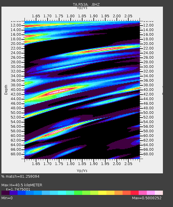
| Estimated Moho Depth: |
40.5 km |
| Estimated Crust Vp/Vs: |
1.75 |
| Assumed Crust Vp: |
6.207 km/s |
| Estimated Crust Vs: |
3.552 km/s |
| Estimated Crust Poisson's Ratio: |
0.26 |
|
| Radial Match: |
81.259094 % |
| Radial Bump: |
400 |
| Transverse Match: |
53.94653 % |
| Transverse Bump: |
400 |
| SOD ConfigId: |
506122 |
| Insert Time: |
2013-05-26 03:44:55.445 +0000 |
| GWidth: |
2.5 |
| Max Bumps: |
400 |
| Tol: |
0.001 |
|

Signal To Noise
| Channel | StoN | STA | LTA |
| TA:R53A: :BHZ:20130313T03:23:22.20002Z | 2.8042145 | 1.2855268E-6 | 4.584267E-7 |
| TA:R53A: :BHN:20130313T03:23:22.20002Z | 1.3645644 | 3.7325063E-7 | 2.7353096E-7 |
| TA:R53A: :BHE:20130313T03:23:22.20002Z | 0.83283085 | 2.2373409E-7 | 2.686429E-7 |
| Arrivals |
| Ps | 5.1 SECOND |
| PpPs | 17 SECOND |
| PsPs/PpSs | 22 SECOND |


