You are here: Home > Network List > TA - USArray Transportable Network (new EarthScope stations) Stations List
> Station W59A Clinton, NC, USA > Earthquake Result Viewer
W59A Clinton, NC, USA - Earthquake Result Viewer
| Earthquake location: |
Eastern Siberia, Russia |
| Earthquake latitude/longitude: |
60.2/163.4 |
| Earthquake time(UTC): |
2013/03/13 (072) 03:12:52 GMT |
| Earthquake Depth: |
5.0 km |
| Earthquake Magnitude: |
5.7 MB, 5.6 MS, 5.8 MW, 5.8 MW |
| Earthquake Catalog/Contributor: |
WHDF/NEIC |
|
| Network: |
TA USArray Transportable Network (new EarthScope stations) |
| Station: |
W59A Clinton, NC, USA |
| Lat/Lon: |
35.17 N/78.44 W |
| Elevation: |
60 m |
|
| Distance: |
72.3 deg |
| Az: |
49.307 deg |
| Baz: |
332.497 deg |
| Ray Param: |
0.053759877 |
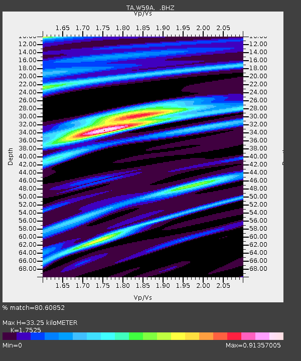
| Estimated Moho Depth: |
33.25 km |
| Estimated Crust Vp/Vs: |
1.75 |
| Assumed Crust Vp: |
6.565 km/s |
| Estimated Crust Vs: |
3.746 km/s |
| Estimated Crust Poisson's Ratio: |
0.26 |
|
| Radial Match: |
80.60852 % |
| Radial Bump: |
400 |
| Transverse Match: |
75.79054 % |
| Transverse Bump: |
400 |
| SOD ConfigId: |
506122 |
| Insert Time: |
2013-05-26 03:45:58.404 +0000 |
| GWidth: |
2.5 |
| Max Bumps: |
400 |
| Tol: |
0.001 |
|
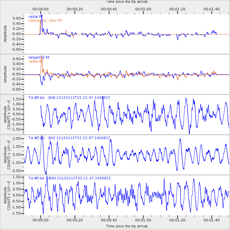
Signal To Noise
| Channel | StoN | STA | LTA |
| TA:W59A: :BHZ:20130313T03:23:47.349983Z | 1.5897028 | 1.516821E-6 | 9.541538E-7 |
| TA:W59A: :BHN:20130313T03:23:47.349983Z | 1.2899762 | 7.483044E-7 | 5.800916E-7 |
| TA:W59A: :BHE:20130313T03:23:47.349983Z | 1.3793025 | 8.468762E-7 | 6.1398873E-7 |
| Arrivals |
| Ps | 4.0 SECOND |
| PpPs | 13 SECOND |
| PsPs/PpSs | 17 SECOND |


