You are here: Home > Network List > GT - Global Telemetered Seismograph Network (USAF/USGS) Stations List
> Station LPAZ La Paz , Bolivia > Earthquake Result Viewer
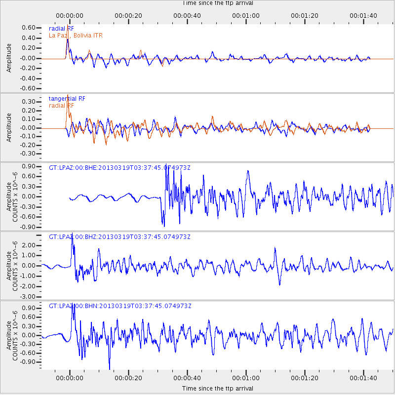
LPAZ La Paz , Bolivia - Earthquake Result Viewer
*The percent match for this event was below the threshold and hence no stack was calculated.
| Earthquake location: |
South Sandwich Islands Region |
| Earthquake latitude/longitude: |
-58.9/-24.3 |
| Earthquake time(UTC): |
2013/03/19 (078) 03:28:58 GMT |
| Earthquake Depth: |
20 km |
| Earthquake Magnitude: |
6.0 MB, 5.8 MS, 5.9 MW, 6.0 MW |
| Earthquake Catalog/Contributor: |
WHDF/NEIC |
|
| Network: |
GT Global Telemetered Seismograph Network (USAF/USGS) |
| Station: |
LPAZ La Paz , Bolivia |
| Lat/Lon: |
16.17 S/68.08 W |
| Elevation: |
4817 m |
|
| Distance: |
53.3 deg |
| Az: |
304.081 deg |
| Baz: |
153.416 deg |
| Ray Param: |
$rayparam |
*The percent match for this event was below the threshold and hence was not used in the summary stack. |
|
| Radial Match: |
76.203674 % |
| Radial Bump: |
400 |
| Transverse Match: |
61.438236 % |
| Transverse Bump: |
400 |
| SOD ConfigId: |
506627 |
| Insert Time: |
2013-06-01 12:50:40.559 +0000 |
| GWidth: |
2.5 |
| Max Bumps: |
400 |
| Tol: |
0.001 |
|
Signal To Noise
| Channel | StoN | STA | LTA |
| GT:LPAZ:00:BHZ:20130319T03:37:45.074973Z | 7.3094916 | 1.1553032E-6 | 1.580552E-7 |
| GT:LPAZ:00:BHN:20130319T03:37:45.074973Z | 7.16456 | 4.8086247E-7 | 6.7116815E-8 |
| GT:LPAZ:00:BHE:20130319T03:37:45.074973Z | 6.5741177 | 4.3618402E-7 | 6.634868E-8 |
| Arrivals |
| Ps | |
| PpPs | |
| PsPs/PpSs | |


