You are here: Home > Network List > CI - Caltech Regional Seismic Network Stations List
> Station GSC Goldstone, Goldstone Lake, CA, USA > Earthquake Result Viewer
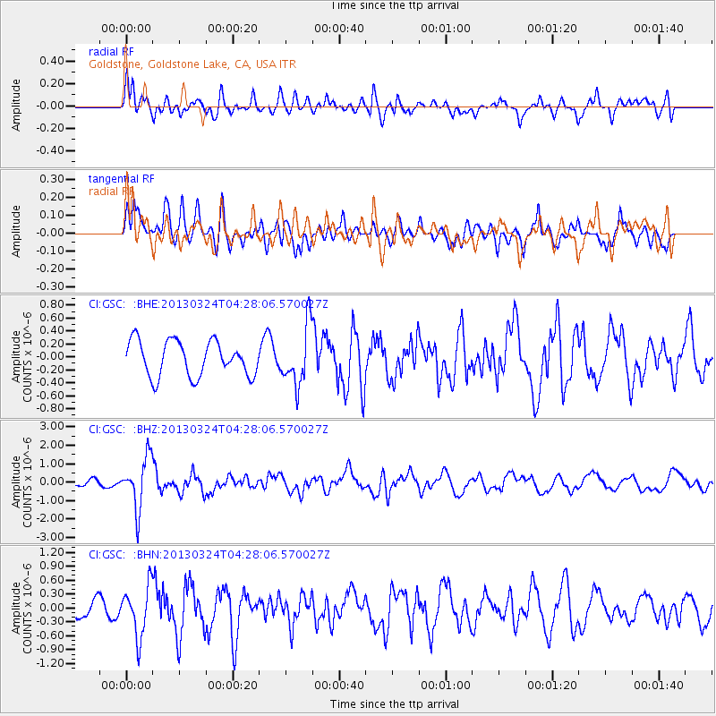
GSC Goldstone, Goldstone Lake, CA, USA - Earthquake Result Viewer
*The percent match for this event was below the threshold and hence no stack was calculated.
| Earthquake location: |
East Of Kuril Islands |
| Earthquake latitude/longitude: |
50.7/160.2 |
| Earthquake time(UTC): |
2013/03/24 (083) 04:18:33 GMT |
| Earthquake Depth: |
8.0 km |
| Earthquake Magnitude: |
6.1 MB, 5.5 MS, 5.9 MW, 6.1 MW |
| Earthquake Catalog/Contributor: |
WHDF/NEIC |
|
| Network: |
CI Caltech Regional Seismic Network |
| Station: |
GSC Goldstone, Goldstone Lake, CA, USA |
| Lat/Lon: |
35.30 N/116.81 W |
| Elevation: |
1000 m |
|
| Distance: |
59.5 deg |
| Az: |
70.405 deg |
| Baz: |
312.949 deg |
| Ray Param: |
$rayparam |
*The percent match for this event was below the threshold and hence was not used in the summary stack. |
|
| Radial Match: |
54.13333 % |
| Radial Bump: |
400 |
| Transverse Match: |
66.57589 % |
| Transverse Bump: |
400 |
| SOD ConfigId: |
506122 |
| Insert Time: |
2013-06-01 12:58:52.683 +0000 |
| GWidth: |
2.5 |
| Max Bumps: |
400 |
| Tol: |
0.001 |
|
Signal To Noise
| Channel | StoN | STA | LTA |
| CI:GSC: :BHZ:20130324T04:28:06.570027Z | 3.980596 | 1.3970699E-6 | 3.5097003E-7 |
| CI:GSC: :BHN:20130324T04:28:06.570027Z | 1.6447932 | 5.473794E-7 | 3.3279528E-7 |
| CI:GSC: :BHE:20130324T04:28:06.570027Z | 1.6951458 | 4.5905E-7 | 2.7080264E-7 |
| Arrivals |
| Ps | |
| PpPs | |
| PsPs/PpSs | |


