You are here: Home > Network List > CI - Caltech Regional Seismic Network Stations List
> Station DAN Danby, California, USA > Earthquake Result Viewer
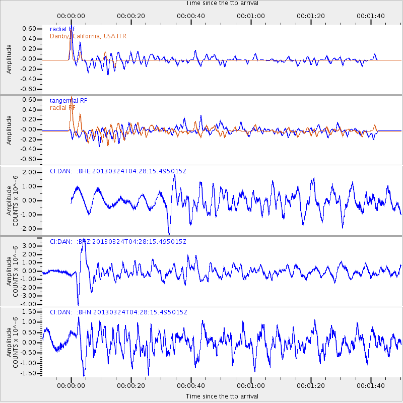
DAN Danby, California, USA - Earthquake Result Viewer
*The percent match for this event was below the threshold and hence no stack was calculated.
| Earthquake location: |
East Of Kuril Islands |
| Earthquake latitude/longitude: |
50.7/160.2 |
| Earthquake time(UTC): |
2013/03/24 (083) 04:18:33 GMT |
| Earthquake Depth: |
8.0 km |
| Earthquake Magnitude: |
6.1 MB, 5.5 MS, 5.9 MW, 6.1 MW |
| Earthquake Catalog/Contributor: |
WHDF/NEIC |
|
| Network: |
CI Caltech Regional Seismic Network |
| Station: |
DAN Danby, California, USA |
| Lat/Lon: |
34.64 N/115.38 W |
| Elevation: |
398 m |
|
| Distance: |
60.8 deg |
| Az: |
70.037 deg |
| Baz: |
313.579 deg |
| Ray Param: |
$rayparam |
*The percent match for this event was below the threshold and hence was not used in the summary stack. |
|
| Radial Match: |
74.31996 % |
| Radial Bump: |
400 |
| Transverse Match: |
64.461205 % |
| Transverse Bump: |
400 |
| SOD ConfigId: |
506122 |
| Insert Time: |
2013-06-01 13:00:28.025 +0000 |
| GWidth: |
2.5 |
| Max Bumps: |
400 |
| Tol: |
0.001 |
|
Signal To Noise
| Channel | StoN | STA | LTA |
| CI:DAN: :BHZ:20130324T04:28:15.495015Z | 10.747782 | 2.1205951E-6 | 1.9730537E-7 |
| CI:DAN: :BHN:20130324T04:28:15.495015Z | 1.9984764 | 8.152288E-7 | 4.0792514E-7 |
| CI:DAN: :BHE:20130324T04:28:15.495015Z | 2.4829495 | 1.1069496E-6 | 4.4582043E-7 |
| Arrivals |
| Ps | |
| PpPs | |
| PsPs/PpSs | |


