You are here: Home > Network List > G - GEOSCOPE Stations List
> Station UNM Unam,Mexico > Earthquake Result Viewer
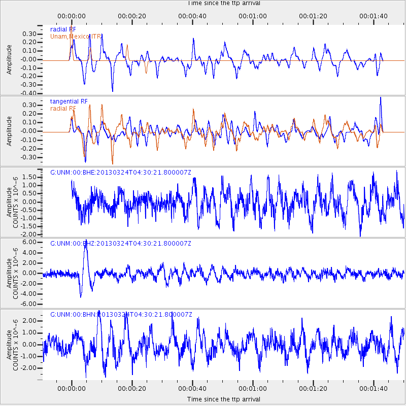
UNM Unam,Mexico - Earthquake Result Viewer
*The percent match for this event was below the threshold and hence no stack was calculated.
| Earthquake location: |
East Of Kuril Islands |
| Earthquake latitude/longitude: |
50.7/160.2 |
| Earthquake time(UTC): |
2013/03/24 (083) 04:18:33 GMT |
| Earthquake Depth: |
8.0 km |
| Earthquake Magnitude: |
6.1 MB, 5.5 MS, 5.9 MW, 6.1 MW |
| Earthquake Catalog/Contributor: |
WHDF/NEIC |
|
| Network: |
G GEOSCOPE |
| Station: |
UNM Unam,Mexico |
| Lat/Lon: |
19.33 N/99.18 W |
| Elevation: |
2280 m |
|
| Distance: |
81.8 deg |
| Az: |
69.661 deg |
| Baz: |
320.875 deg |
| Ray Param: |
$rayparam |
*The percent match for this event was below the threshold and hence was not used in the summary stack. |
|
| Radial Match: |
80.35676 % |
| Radial Bump: |
384 |
| Transverse Match: |
76.907074 % |
| Transverse Bump: |
400 |
| SOD ConfigId: |
506122 |
| Insert Time: |
2013-06-01 13:03:36.354 +0000 |
| GWidth: |
2.5 |
| Max Bumps: |
400 |
| Tol: |
0.001 |
|
Signal To Noise
| Channel | StoN | STA | LTA |
| G:UNM:00:BHZ:20130324T04:30:21.800007Z | 7.0511885 | 2.620085E-6 | 3.7158065E-7 |
| G:UNM:00:BHN:20130324T04:30:21.800007Z | 1.7305282 | 8.6341373E-7 | 4.989307E-7 |
| G:UNM:00:BHE:20130324T04:30:21.800007Z | 0.739328 | 3.73079E-7 | 5.04619E-7 |
| Arrivals |
| Ps | |
| PpPs | |
| PsPs/PpSs | |


