You are here: Home > Network List > TA - USArray Transportable Network (new EarthScope stations) Stations List
> Station K40A Colesburg, IA, USA > Earthquake Result Viewer
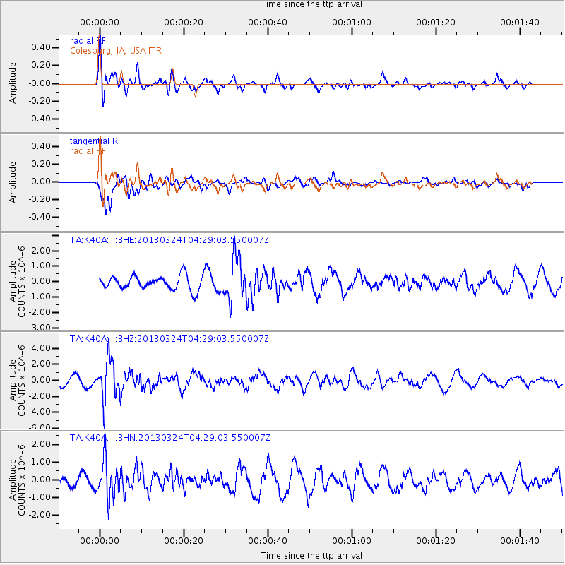
K40A Colesburg, IA, USA - Earthquake Result Viewer
*The percent match for this event was below the threshold and hence no stack was calculated.
| Earthquake location: |
East Of Kuril Islands |
| Earthquake latitude/longitude: |
50.7/160.2 |
| Earthquake time(UTC): |
2013/03/24 (083) 04:18:33 GMT |
| Earthquake Depth: |
8.0 km |
| Earthquake Magnitude: |
6.1 MB, 5.5 MS, 5.9 MW, 6.1 MW |
| Earthquake Catalog/Contributor: |
WHDF/NEIC |
|
| Network: |
TA USArray Transportable Network (new EarthScope stations) |
| Station: |
K40A Colesburg, IA, USA |
| Lat/Lon: |
42.70 N/91.14 W |
| Elevation: |
274 m |
|
| Distance: |
68.2 deg |
| Az: |
48.77 deg |
| Baz: |
319.583 deg |
| Ray Param: |
$rayparam |
*The percent match for this event was below the threshold and hence was not used in the summary stack. |
|
| Radial Match: |
55.308765 % |
| Radial Bump: |
400 |
| Transverse Match: |
70.09118 % |
| Transverse Bump: |
400 |
| SOD ConfigId: |
506122 |
| Insert Time: |
2013-06-01 13:15:22.783 +0000 |
| GWidth: |
2.5 |
| Max Bumps: |
400 |
| Tol: |
0.001 |
|
Signal To Noise
| Channel | StoN | STA | LTA |
| TA:K40A: :BHZ:20130324T04:29:03.550007Z | 5.841571 | 2.46785E-6 | 4.2246342E-7 |
| TA:K40A: :BHN:20130324T04:29:03.550007Z | 4.1826468 | 1.0629656E-6 | 2.5413706E-7 |
| TA:K40A: :BHE:20130324T04:29:03.550007Z | 3.0844123 | 1.3857843E-6 | 4.4928632E-7 |
| Arrivals |
| Ps | |
| PpPs | |
| PsPs/PpSs | |


