You are here: Home > Network List > GT - Global Telemetered Seismograph Network (USAF/USGS) Stations List
> Station LBTB Lobatse, Botswana, Africa > Earthquake Result Viewer
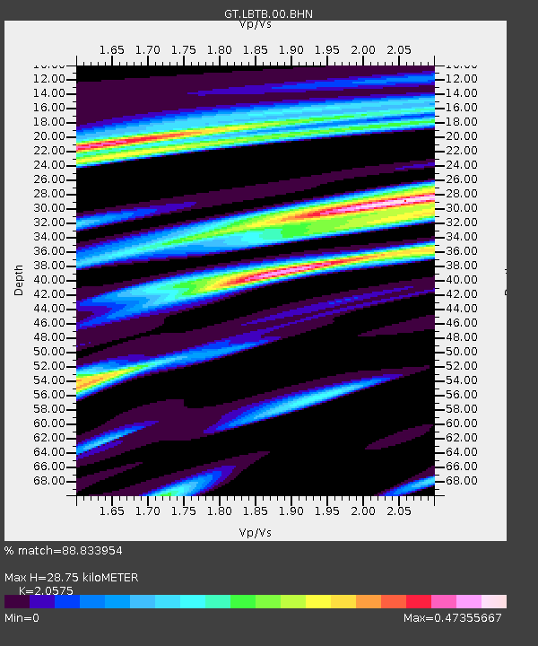
LBTB Lobatse, Botswana, Africa - Earthquake Result Viewer
| Earthquake location: |
South Sandwich Islands Region |
| Earthquake latitude/longitude: |
-55.4/-29.5 |
| Earthquake time(UTC): |
2007/01/20 (020) 06:21:04 GMT |
| Earthquake Depth: |
10 km |
| Earthquake Magnitude: |
5.7 MB, 6.2 MS, 6.2 MW, 6.1 MW |
| Earthquake Catalog/Contributor: |
WHDF/NEIC |
|
| Network: |
GT Global Telemetered Seismograph Network (USAF/USGS) |
| Station: |
LBTB Lobatse, Botswana, Africa |
| Lat/Lon: |
25.02 S/25.60 E |
| Elevation: |
1128 m |
|
| Distance: |
50.1 deg |
| Az: |
75.943 deg |
| Baz: |
217.561 deg |
| Ray Param: |
0.068268895 |
| Estimated Moho Depth: |
28.75 km |
| Estimated Crust Vp/Vs: |
2.06 |
| Assumed Crust Vp: |
6.459 km/s |
| Estimated Crust Vs: |
3.139 km/s |
| Estimated Crust Poisson's Ratio: |
0.35 |
|
| Radial Match: |
88.833954 % |
| Radial Bump: |
345 |
| Transverse Match: |
72.6026 % |
| Transverse Bump: |
400 |
| SOD ConfigId: |
2564 |
| Insert Time: |
2010-02-27 02:03:47.293 +0000 |
| GWidth: |
2.5 |
| Max Bumps: |
400 |
| Tol: |
0.001 |
|

Signal To Noise
| Channel | StoN | STA | LTA |
| GT:LBTB:00:BHN:20070120T06:29:28.825015Z | 4.9104977 | 6.833239E-7 | 1.3915573E-7 |
| GT:LBTB:00:BHE:20070120T06:29:28.825015Z | 2.4921062 | 6.189865E-7 | 2.4837888E-7 |
| GT:LBTB:00:BHZ:20070120T06:29:28.825015Z | 5.2507873 | 1.4702175E-6 | 2.7999943E-7 |
| Arrivals |
| Ps | 5.0 SECOND |
| PpPs | 13 SECOND |
| PsPs/PpSs | 18 SECOND |


