You are here: Home > Network List > TA - USArray Transportable Network (new EarthScope stations) Stations List
> Station L39A Vinton, IA, USA > Earthquake Result Viewer
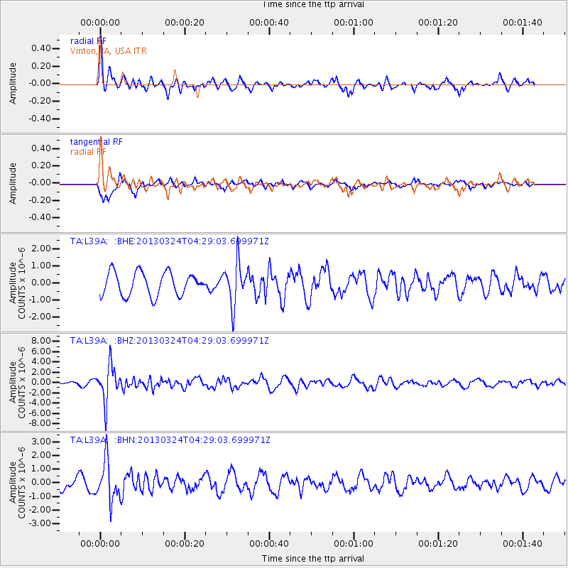
L39A Vinton, IA, USA - Earthquake Result Viewer
*The percent match for this event was below the threshold and hence no stack was calculated.
| Earthquake location: |
East Of Kuril Islands |
| Earthquake latitude/longitude: |
50.7/160.2 |
| Earthquake time(UTC): |
2013/03/24 (083) 04:18:33 GMT |
| Earthquake Depth: |
8.0 km |
| Earthquake Magnitude: |
6.1 MB, 5.5 MS, 5.9 MW, 6.1 MW |
| Earthquake Catalog/Contributor: |
WHDF/NEIC |
|
| Network: |
TA USArray Transportable Network (new EarthScope stations) |
| Station: |
L39A Vinton, IA, USA |
| Lat/Lon: |
42.12 N/92.00 W |
| Elevation: |
261 m |
|
| Distance: |
68.2 deg |
| Az: |
49.696 deg |
| Baz: |
319.347 deg |
| Ray Param: |
$rayparam |
*The percent match for this event was below the threshold and hence was not used in the summary stack. |
|
| Radial Match: |
62.3186 % |
| Radial Bump: |
351 |
| Transverse Match: |
64.920975 % |
| Transverse Bump: |
368 |
| SOD ConfigId: |
506122 |
| Insert Time: |
2013-06-01 13:15:47.493 +0000 |
| GWidth: |
2.5 |
| Max Bumps: |
400 |
| Tol: |
0.001 |
|
Signal To Noise
| Channel | StoN | STA | LTA |
| TA:L39A: :BHZ:20130324T04:29:03.699971Z | 6.2814612 | 3.5023397E-6 | 5.575677E-7 |
| TA:L39A: :BHN:20130324T04:29:03.699971Z | 3.5630713 | 1.4616662E-6 | 4.102265E-7 |
| TA:L39A: :BHE:20130324T04:29:03.699971Z | 1.8323034 | 1.2366152E-6 | 6.748965E-7 |
| Arrivals |
| Ps | |
| PpPs | |
| PsPs/PpSs | |


