You are here: Home > Network List > CI - Caltech Regional Seismic Network Stations List
> Station MPP McPhearson Peak > Earthquake Result Viewer
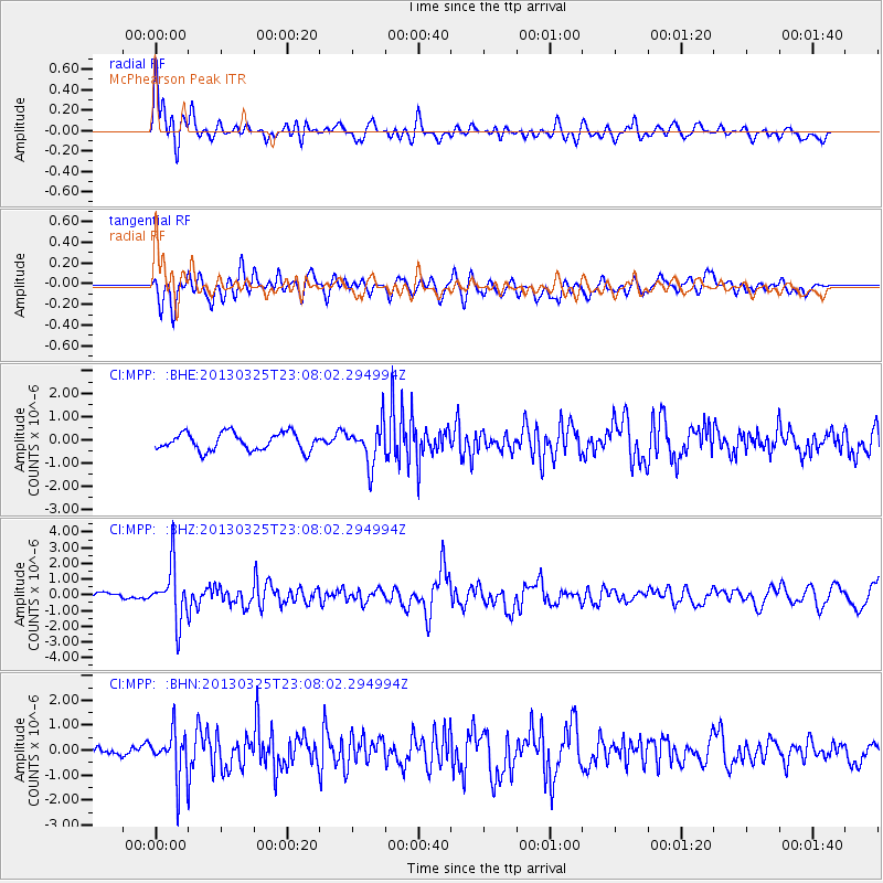
MPP McPhearson Peak - Earthquake Result Viewer
*The percent match for this event was below the threshold and hence no stack was calculated.
| Earthquake location: |
Guatemala |
| Earthquake latitude/longitude: |
14.5/-90.5 |
| Earthquake time(UTC): |
2013/03/25 (084) 23:02:12 GMT |
| Earthquake Depth: |
189 km |
| Earthquake Magnitude: |
6.2 MB, 6.2 MW, 6.2 MW |
| Earthquake Catalog/Contributor: |
WHDF/NEIC |
|
| Network: |
CI Caltech Regional Seismic Network |
| Station: |
MPP McPhearson Peak |
| Lat/Lon: |
34.89 N/119.81 W |
| Elevation: |
1739 m |
|
| Distance: |
33.3 deg |
| Az: |
312.821 deg |
| Baz: |
120.205 deg |
| Ray Param: |
$rayparam |
*The percent match for this event was below the threshold and hence was not used in the summary stack. |
|
| Radial Match: |
79.05173 % |
| Radial Bump: |
400 |
| Transverse Match: |
71.16657 % |
| Transverse Bump: |
400 |
| SOD ConfigId: |
506627 |
| Insert Time: |
2013-06-01 13:15:56.365 +0000 |
| GWidth: |
2.5 |
| Max Bumps: |
400 |
| Tol: |
0.001 |
|
Signal To Noise
| Channel | StoN | STA | LTA |
| CI:MPP: :BHZ:20130325T23:08:02.294994Z | 12.293794 | 1.7278754E-6 | 1.405486E-7 |
| CI:MPP: :BHN:20130325T23:08:02.294994Z | 2.8907979 | 9.4686027E-7 | 3.275429E-7 |
| CI:MPP: :BHE:20130325T23:08:02.294994Z | 2.213447 | 8.484249E-7 | 3.833048E-7 |
| Arrivals |
| Ps | |
| PpPs | |
| PsPs/PpSs | |


