You are here: Home > Network List > TA - USArray Transportable Network (new EarthScope stations) Stations List
> Station Z41A Richland Creek Farm, El Dorado, AR, USA > Earthquake Result Viewer
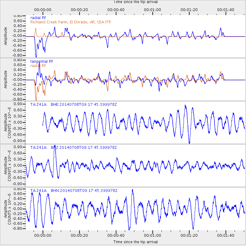
Z41A Richland Creek Farm, El Dorado, AR, USA - Earthquake Result Viewer
*The percent match for this event was below the threshold and hence no stack was calculated.
| Earthquake location: |
Hokkaido, Japan Region |
| Earthquake latitude/longitude: |
42.7/141.4 |
| Earthquake time(UTC): |
2014/07/08 (189) 09:05:23 GMT |
| Earthquake Depth: |
10 km |
| Earthquake Magnitude: |
5.6 MB, 5.5 MWB |
| Earthquake Catalog/Contributor: |
NEIC PDE/NEIC COMCAT |
|
| Network: |
TA USArray Transportable Network (new EarthScope stations) |
| Station: |
Z41A Richland Creek Farm, El Dorado, AR, USA |
| Lat/Lon: |
33.26 N/92.80 W |
| Elevation: |
62 m |
|
| Distance: |
89.6 deg |
| Az: |
42.822 deg |
| Baz: |
323.259 deg |
| Ray Param: |
$rayparam |
*The percent match for this event was below the threshold and hence was not used in the summary stack. |
|
| Radial Match: |
63.450768 % |
| Radial Bump: |
399 |
| Transverse Match: |
47.112877 % |
| Transverse Bump: |
386 |
| SOD ConfigId: |
3390531 |
| Insert Time: |
2019-04-12 18:29:42.718 +0000 |
| GWidth: |
2.5 |
| Max Bumps: |
400 |
| Tol: |
0.001 |
|
Signal To Noise
| Channel | StoN | STA | LTA |
| TA:Z41A: :BHZ:20140708T09:17:45.399978Z | 0.89931774 | 1.9283091E-7 | 2.1441912E-7 |
| TA:Z41A: :BHN:20140708T09:17:45.399978Z | 1.3692305 | 4.5843365E-7 | 3.3481118E-7 |
| TA:Z41A: :BHE:20140708T09:17:45.399978Z | 1.4849288 | 4.1033098E-7 | 2.763304E-7 |
| Arrivals |
| Ps | |
| PpPs | |
| PsPs/PpSs | |


