You are here: Home > Network List > UW - Pacific Northwest Regional Seismic Network Stations List
> Station UMAT Pilot Rock, OR, USA > Earthquake Result Viewer
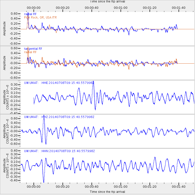
UMAT Pilot Rock, OR, USA - Earthquake Result Viewer
*The percent match for this event was below the threshold and hence no stack was calculated.
| Earthquake location: |
Hokkaido, Japan Region |
| Earthquake latitude/longitude: |
42.7/141.4 |
| Earthquake time(UTC): |
2014/07/08 (189) 09:05:23 GMT |
| Earthquake Depth: |
10 km |
| Earthquake Magnitude: |
5.6 MB, 5.5 MWB |
| Earthquake Catalog/Contributor: |
NEIC PDE/NEIC COMCAT |
|
| Network: |
UW Pacific Northwest Regional Seismic Network |
| Station: |
UMAT Pilot Rock, OR, USA |
| Lat/Lon: |
45.29 N/118.96 W |
| Elevation: |
1318 m |
|
| Distance: |
67.0 deg |
| Az: |
49.137 deg |
| Baz: |
307.812 deg |
| Ray Param: |
$rayparam |
*The percent match for this event was below the threshold and hence was not used in the summary stack. |
|
| Radial Match: |
72.406105 % |
| Radial Bump: |
400 |
| Transverse Match: |
54.958935 % |
| Transverse Bump: |
400 |
| SOD ConfigId: |
3390531 |
| Insert Time: |
2019-04-12 18:30:34.878 +0000 |
| GWidth: |
2.5 |
| Max Bumps: |
400 |
| Tol: |
0.001 |
|
Signal To Noise
| Channel | StoN | STA | LTA |
| UW:UMAT: :HHZ:20140708T09:15:40.557998Z | 1.0367707 | 7.0639885E-8 | 6.813453E-8 |
| UW:UMAT: :HHN:20140708T09:15:40.557998Z | 0.69866 | 4.3902418E-8 | 6.2838026E-8 |
| UW:UMAT: :HHE:20140708T09:15:40.557998Z | 1.3026958 | 7.483471E-8 | 5.7446034E-8 |
| Arrivals |
| Ps | |
| PpPs | |
| PsPs/PpSs | |


