You are here: Home > Network List > TA - USArray Transportable Network (new EarthScope stations) Stations List
> Station V52A Sevierville, TN, USA > Earthquake Result Viewer
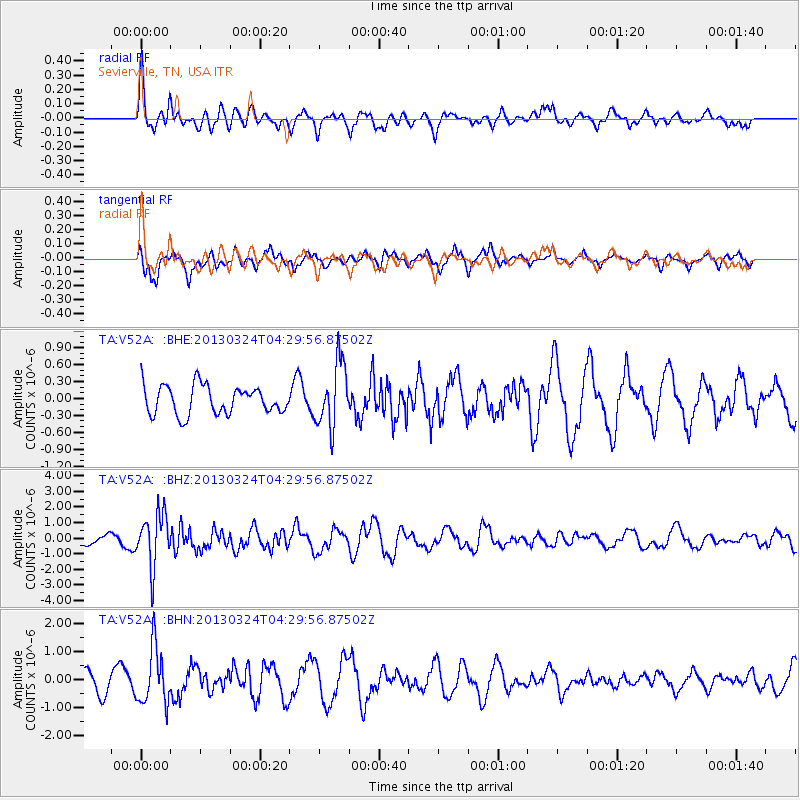
V52A Sevierville, TN, USA - Earthquake Result Viewer
*The percent match for this event was below the threshold and hence no stack was calculated.
| Earthquake location: |
East Of Kuril Islands |
| Earthquake latitude/longitude: |
50.7/160.2 |
| Earthquake time(UTC): |
2013/03/24 (083) 04:18:33 GMT |
| Earthquake Depth: |
8.0 km |
| Earthquake Magnitude: |
6.1 MB, 5.5 MS, 5.9 MW, 6.1 MW |
| Earthquake Catalog/Contributor: |
WHDF/NEIC |
|
| Network: |
TA USArray Transportable Network (new EarthScope stations) |
| Station: |
V52A Sevierville, TN, USA |
| Lat/Lon: |
35.84 N/83.60 W |
| Elevation: |
328 m |
|
| Distance: |
77.2 deg |
| Az: |
48.361 deg |
| Baz: |
324.229 deg |
| Ray Param: |
$rayparam |
*The percent match for this event was below the threshold and hence was not used in the summary stack. |
|
| Radial Match: |
64.28769 % |
| Radial Bump: |
400 |
| Transverse Match: |
62.27606 % |
| Transverse Bump: |
400 |
| SOD ConfigId: |
506122 |
| Insert Time: |
2013-06-01 13:30:34.560 +0000 |
| GWidth: |
2.5 |
| Max Bumps: |
400 |
| Tol: |
0.001 |
|
Signal To Noise
| Channel | StoN | STA | LTA |
| TA:V52A: :BHZ:20130324T04:29:56.87502Z | 3.6903038 | 1.6670601E-6 | 4.5174062E-7 |
| TA:V52A: :BHN:20130324T04:29:56.87502Z | 3.3463812 | 9.95403E-7 | 2.9745655E-7 |
| TA:V52A: :BHE:20130324T04:29:56.87502Z | 2.255458 | 5.655492E-7 | 2.5074695E-7 |
| Arrivals |
| Ps | |
| PpPs | |
| PsPs/PpSs | |


