You are here: Home > Network List > TA - USArray Transportable Network (new EarthScope stations) Stations List
> Station O03E Paynes Creek, CA, USA > Earthquake Result Viewer
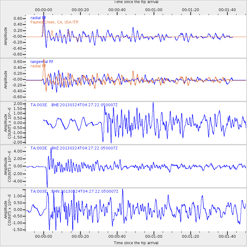
O03E Paynes Creek, CA, USA - Earthquake Result Viewer
*The percent match for this event was below the threshold and hence no stack was calculated.
| Earthquake location: |
East Of Kuril Islands |
| Earthquake latitude/longitude: |
50.7/160.2 |
| Earthquake time(UTC): |
2013/03/24 (083) 04:18:33 GMT |
| Earthquake Depth: |
8.0 km |
| Earthquake Magnitude: |
6.1 MB, 5.5 MS, 5.9 MW, 6.1 MW |
| Earthquake Catalog/Contributor: |
WHDF/NEIC |
|
| Network: |
TA USArray Transportable Network (new EarthScope stations) |
| Station: |
O03E Paynes Creek, CA, USA |
| Lat/Lon: |
40.29 N/121.80 W |
| Elevation: |
967 m |
|
| Distance: |
53.3 deg |
| Az: |
69.016 deg |
| Baz: |
309.125 deg |
| Ray Param: |
$rayparam |
*The percent match for this event was below the threshold and hence was not used in the summary stack. |
|
| Radial Match: |
79.45432 % |
| Radial Bump: |
400 |
| Transverse Match: |
71.484825 % |
| Transverse Bump: |
400 |
| SOD ConfigId: |
506122 |
| Insert Time: |
2013-06-01 13:34:25.745 +0000 |
| GWidth: |
2.5 |
| Max Bumps: |
400 |
| Tol: |
0.001 |
|
Signal To Noise
| Channel | StoN | STA | LTA |
| TA:O03E: :BHZ:20130324T04:27:22.050007Z | 19.408941 | 2.1019969E-6 | 1.0830044E-7 |
| TA:O03E: :BHN:20130324T04:27:22.050007Z | 4.3370767 | 6.5986126E-7 | 1.5214425E-7 |
| TA:O03E: :BHE:20130324T04:27:22.050007Z | 2.432835 | 8.803124E-7 | 3.6184633E-7 |
| Arrivals |
| Ps | |
| PpPs | |
| PsPs/PpSs | |


