You are here: Home > Network List > TA - USArray Transportable Network (new EarthScope stations) Stations List
> Station W54A Cherokee Point, Campobello, SC, USA > Earthquake Result Viewer
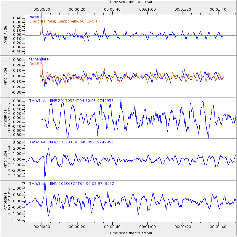
W54A Cherokee Point, Campobello, SC, USA - Earthquake Result Viewer
*The percent match for this event was below the threshold and hence no stack was calculated.
| Earthquake location: |
East Of Kuril Islands |
| Earthquake latitude/longitude: |
50.7/160.2 |
| Earthquake time(UTC): |
2013/03/24 (083) 04:18:33 GMT |
| Earthquake Depth: |
8.0 km |
| Earthquake Magnitude: |
6.1 MB, 5.5 MS, 5.9 MW, 6.1 MW |
| Earthquake Catalog/Contributor: |
WHDF/NEIC |
|
| Network: |
TA USArray Transportable Network (new EarthScope stations) |
| Station: |
W54A Cherokee Point, Campobello, SC, USA |
| Lat/Lon: |
35.09 N/82.19 W |
| Elevation: |
272 m |
|
| Distance: |
78.5 deg |
| Az: |
47.849 deg |
| Baz: |
324.935 deg |
| Ray Param: |
$rayparam |
*The percent match for this event was below the threshold and hence was not used in the summary stack. |
|
| Radial Match: |
48.964157 % |
| Radial Bump: |
324 |
| Transverse Match: |
65.245094 % |
| Transverse Bump: |
400 |
| SOD ConfigId: |
506122 |
| Insert Time: |
2013-06-01 13:39:52.030 +0000 |
| GWidth: |
2.5 |
| Max Bumps: |
400 |
| Tol: |
0.001 |
|
Signal To Noise
| Channel | StoN | STA | LTA |
| TA:W54A: :BHZ:20130324T04:30:03.974995Z | 4.0546985 | 1.3739061E-6 | 3.38843E-7 |
| TA:W54A: :BHN:20130324T04:30:03.974995Z | 3.4448044 | 7.127029E-7 | 2.0689211E-7 |
| TA:W54A: :BHE:20130324T04:30:03.974995Z | 0.9193484 | 3.8032124E-7 | 4.1368565E-7 |
| Arrivals |
| Ps | |
| PpPs | |
| PsPs/PpSs | |


