You are here: Home > Network List > TA - USArray Transportable Network (new EarthScope stations) Stations List
> Station V59A Middlesex, NC, USA > Earthquake Result Viewer
V59A Middlesex, NC, USA - Earthquake Result Viewer
| Earthquake location: |
East Of Kuril Islands |
| Earthquake latitude/longitude: |
50.7/160.2 |
| Earthquake time(UTC): |
2013/03/24 (083) 04:18:33 GMT |
| Earthquake Depth: |
8.0 km |
| Earthquake Magnitude: |
6.1 MB, 5.5 MS, 5.9 MW, 6.1 MW |
| Earthquake Catalog/Contributor: |
WHDF/NEIC |
|
| Network: |
TA USArray Transportable Network (new EarthScope stations) |
| Station: |
V59A Middlesex, NC, USA |
| Lat/Lon: |
35.76 N/78.24 W |
| Elevation: |
58 m |
|
| Distance: |
79.7 deg |
| Az: |
44.747 deg |
| Baz: |
326.626 deg |
| Ray Param: |
0.048770048 |
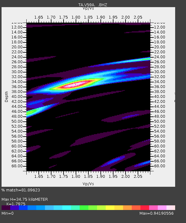
| Estimated Moho Depth: |
34.75 km |
| Estimated Crust Vp/Vs: |
1.80 |
| Assumed Crust Vp: |
6.565 km/s |
| Estimated Crust Vs: |
3.652 km/s |
| Estimated Crust Poisson's Ratio: |
0.28 |
|
| Radial Match: |
81.89623 % |
| Radial Bump: |
400 |
| Transverse Match: |
66.88814 % |
| Transverse Bump: |
400 |
| SOD ConfigId: |
506122 |
| Insert Time: |
2013-06-01 13:41:59.025 +0000 |
| GWidth: |
2.5 |
| Max Bumps: |
400 |
| Tol: |
0.001 |
|
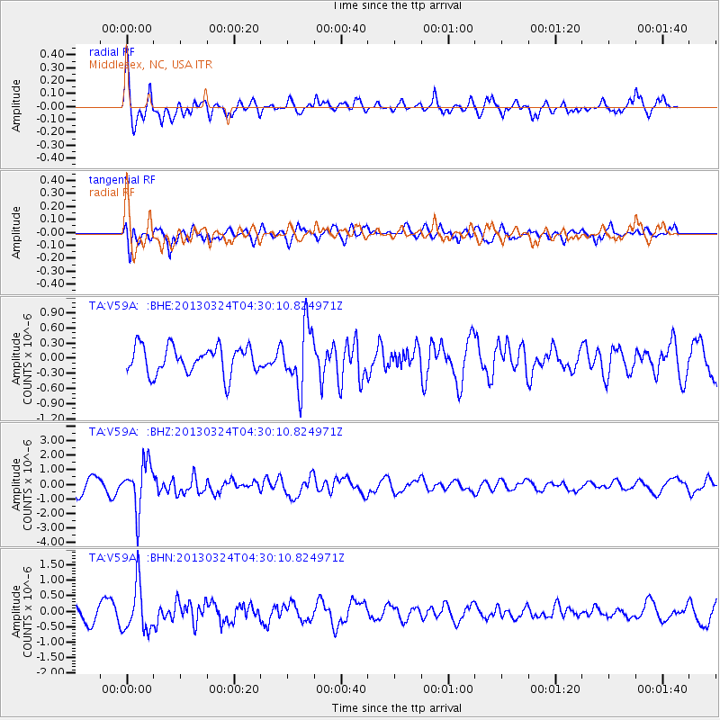
Signal To Noise
| Channel | StoN | STA | LTA |
| TA:V59A: :BHZ:20130324T04:30:10.824971Z | 3.745588 | 1.5917068E-6 | 4.249551E-7 |
| TA:V59A: :BHN:20130324T04:30:10.824971Z | 2.9839568 | 7.723766E-7 | 2.5884307E-7 |
| TA:V59A: :BHE:20130324T04:30:10.824971Z | 2.2054052 | 6.0031215E-7 | 2.722004E-7 |
| Arrivals |
| Ps | 4.3 SECOND |
| PpPs | 14 SECOND |
| PsPs/PpSs | 19 SECOND |


