You are here: Home > Network List > GT - Global Telemetered Seismograph Network (USAF/USGS) Stations List
> Station LBTB Lobatse, Botswana, Africa > Earthquake Result Viewer
LBTB Lobatse, Botswana, Africa - Earthquake Result Viewer
| Earthquake location: |
South Of Australia |
| Earthquake latitude/longitude: |
-42.8/124.7 |
| Earthquake time(UTC): |
2001/12/12 (346) 14:02:35 GMT |
| Earthquake Depth: |
10 km |
| Earthquake Magnitude: |
6.5 MB, 6.7 MS, 7.1 MW, 7.0 MW |
| Earthquake Catalog/Contributor: |
WHDF/NEIC |
|
| Network: |
GT Global Telemetered Seismograph Network (USAF/USGS) |
| Station: |
LBTB Lobatse, Botswana, Africa |
| Lat/Lon: |
25.02 S/25.60 E |
| Elevation: |
1128 m |
|
| Distance: |
79.7 deg |
| Az: |
245.593 deg |
| Baz: |
132.39 deg |
| Ray Param: |
0.048799902 |
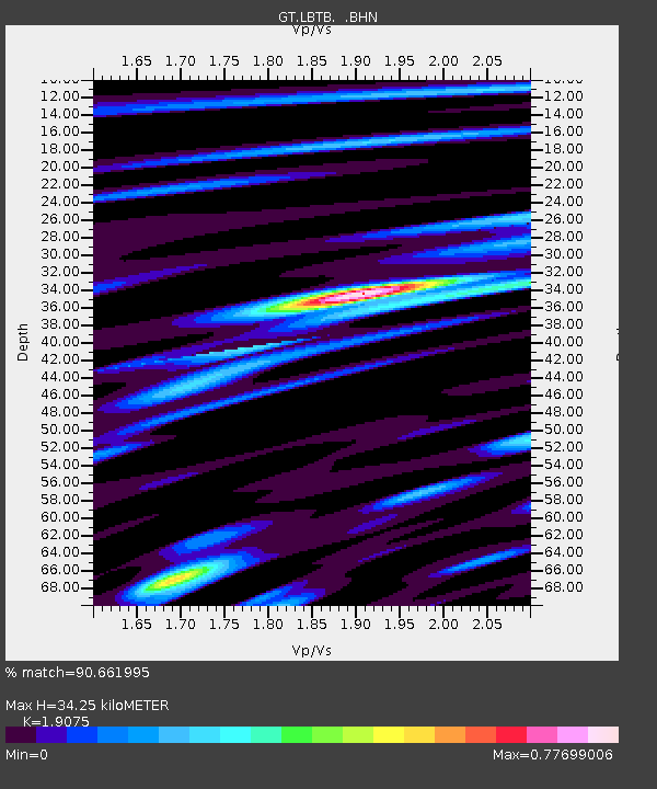
| Estimated Moho Depth: |
34.25 km |
| Estimated Crust Vp/Vs: |
1.91 |
| Assumed Crust Vp: |
6.459 km/s |
| Estimated Crust Vs: |
3.386 km/s |
| Estimated Crust Poisson's Ratio: |
0.31 |
|
| Radial Match: |
90.661995 % |
| Radial Bump: |
400 |
| Transverse Match: |
82.60122 % |
| Transverse Bump: |
400 |
| SOD ConfigId: |
20082 |
| Insert Time: |
2010-02-27 02:05:13.841 +0000 |
| GWidth: |
2.5 |
| Max Bumps: |
400 |
| Tol: |
0.001 |
|

Signal To Noise
| Channel | StoN | STA | LTA |
| GT:LBTB: :BHN:20011212T14:14:11.284019Z | 1.4317486 | 2.513799E-7 | 1.7557544E-7 |
| GT:LBTB: :BHE:20011212T14:14:11.284019Z | 1.0061408 | 1.5081986E-7 | 1.4989935E-7 |
| GT:LBTB: :BHZ:20011212T14:14:11.284019Z | 4.103008 | 7.70335E-7 | 1.8774885E-7 |
| Arrivals |
| Ps | 4.9 SECOND |
| PpPs | 15 SECOND |
| PsPs/PpSs | 20 SECOND |


