You are here: Home > Network List > GT - Global Telemetered Seismograph Network (USAF/USGS) Stations List
> Station LBTB Lobatse, Botswana, Africa > Earthquake Result Viewer
LBTB Lobatse, Botswana, Africa - Earthquake Result Viewer

| Earthquake location: |
Near Coast Of Peru |
| Earthquake latitude/longitude: |
-17.8/-71.3 |
| Earthquake time(UTC): |
2001/06/23 (174) 21:05:39 GMT |
| Earthquake Depth: |
33 km |
| Earthquake Magnitude: |
5.8 MB |
| Earthquake Catalog/Contributor: |
WHDF/NEIC |
|
| Network: |
GT Global Telemetered Seismograph Network (USAF/USGS) |
| Station: |
LBTB Lobatse, Botswana, Africa |
| Lat/Lon: |
25.02 S/25.60 E |
| Elevation: |
1128 m |
|
| Distance: |
88.6 deg |
| Az: |
115.727 deg |
| Baz: |
251.047 deg |
| Ray Param: |
0.042386282 |
| Estimated Moho Depth: |
16.0 km |
| Estimated Crust Vp/Vs: |
1.60 |
| Assumed Crust Vp: |
6.459 km/s |
| Estimated Crust Vs: |
4.037 km/s |
| Estimated Crust Poisson's Ratio: |
0.18 |
|
| Radial Match: |
98.85163 % |
| Radial Bump: |
203 |
| Transverse Match: |
84.73466 % |
| Transverse Bump: |
352 |
| SOD ConfigId: |
3753 |
| Insert Time: |
2010-02-27 02:05:18.315 +0000 |
| GWidth: |
2.5 |
| Max Bumps: |
400 |
| Tol: |
0.001 |
|
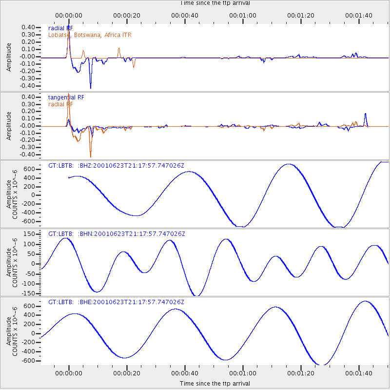
Signal To Noise
| Channel | StoN | STA | LTA |
| GT:LBTB: :BHN:20010623T21:17:57.747026Z | 4.1496086 | 1.03479746E-4 | 2.4937232E-5 |
| GT:LBTB: :BHE:20010623T21:17:57.747026Z | 3.9003499 | 5.5071444E-4 | 1.4119617E-4 |
| GT:LBTB: :BHZ:20010623T21:17:57.747026Z | 0.43530664 | 1.5455666E-4 | 3.5505238E-4 |
| Arrivals |
| Ps | 1.5 SECOND |
| PpPs | 6.3 SECOND |
| PsPs/PpSs | 7.8 SECOND |


