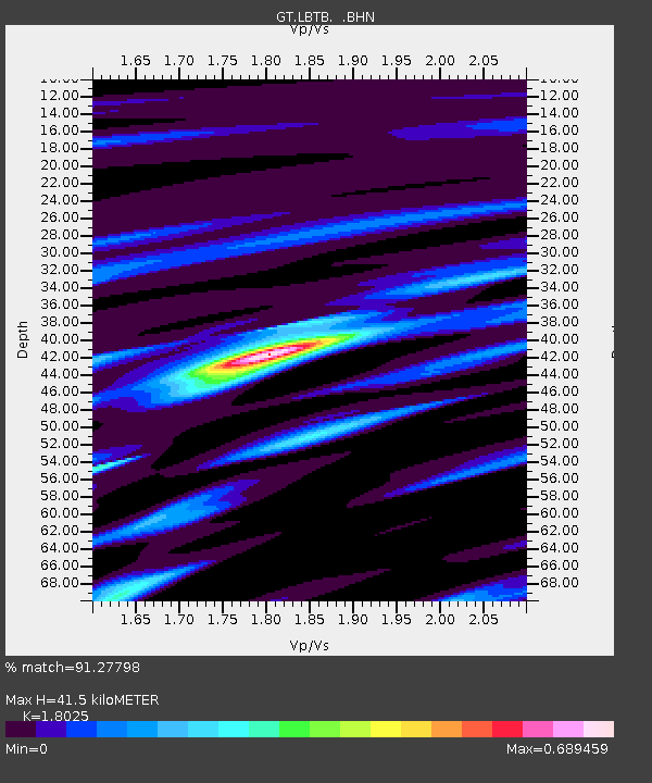
LBTB Lobatse, Botswana, Africa - Earthquake Result Viewer

Earthquake location: Southern Sumatra, Indonesia
Earthquake latitude/longitude: -4.7/102.6
Earthquake time(UTC): 2001/02/13 (044) 19:28:30 GMT
Earthquake Depth: 36 km
Earthquake Magnitude: 6.2 MB, 7.2 MS, 7.4 MW, 7.0 ME
Earthquake Catalog/Contributor: WHDF/NEIC
Network: GT Global Telemetered Seismograph Network (USAF/USGS)
Station: LBTB Lobatse, Botswana, Africa
Lat/Lon: 25.02 S/25.60 E
Elevation: 1128 m
Distance: 76.2 deg
Az: 245.514 deg
Baz: 88.761 deg
Ray Param: 0.05108071
Estimated Moho Depth: 41.5 km
Estimated Crust Vp/Vs: 1.80
Assumed Crust Vp: 6.459 km/s
Estimated Crust Vs: 3.584 km/s
Estimated Crust Poisson's Ratio: 0.28
Radial Match: 91.27798 %
Radial Bump: 337
Transverse Match: 82.31122 %
Transverse Bump: 400
SOD ConfigId: 3744
Insert Time: 2010-02-27 02:05:19.471 +0000
GWidth: 2.5
Max Bumps: 400
Tol: 0.001

Signal To Noise

ChannelStoNSTALTA
GT:LBTB: :BHN:20010213T19:39:44.023Z1.11015642.781143E-72.5051813E-7
GT:LBTB: :BHE:20010213T19:39:44.023Z0.686122662.037715E-72.969899E-7
GT:LBTB: :BHZ:20010213T19:39:44.023Z1.29098923.97567E-73.0795533E-7
Arrivals
Ps5.3 SECOND
PpPs17 SECOND
PsPs/PpSs23 SECOND