You are here: Home > Network List > TA - USArray Transportable Network (new EarthScope stations) Stations List
> Station H17A Grant Village (NPS), Yellowstone Nt. Park, WY, USA > Earthquake Result Viewer
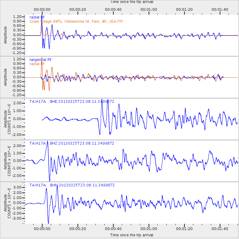
H17A Grant Village (NPS), Yellowstone Nt. Park, WY, USA - Earthquake Result Viewer
*The percent match for this event was below the threshold and hence no stack was calculated.
| Earthquake location: |
Guatemala |
| Earthquake latitude/longitude: |
14.5/-90.5 |
| Earthquake time(UTC): |
2013/03/25 (084) 23:02:12 GMT |
| Earthquake Depth: |
189 km |
| Earthquake Magnitude: |
6.2 MB, 6.2 MW, 6.2 MW |
| Earthquake Catalog/Contributor: |
WHDF/NEIC |
|
| Network: |
TA USArray Transportable Network (new EarthScope stations) |
| Station: |
H17A Grant Village (NPS), Yellowstone Nt. Park, WY, USA |
| Lat/Lon: |
44.40 N/110.58 W |
| Elevation: |
2400 m |
|
| Distance: |
34.4 deg |
| Az: |
334.113 deg |
| Baz: |
143.849 deg |
| Ray Param: |
$rayparam |
*The percent match for this event was below the threshold and hence was not used in the summary stack. |
|
| Radial Match: |
71.85861 % |
| Radial Bump: |
400 |
| Transverse Match: |
67.29734 % |
| Transverse Bump: |
400 |
| SOD ConfigId: |
506122 |
| Insert Time: |
2013-06-01 13:54:05.070 +0000 |
| GWidth: |
2.5 |
| Max Bumps: |
400 |
| Tol: |
0.001 |
|
Signal To Noise
| Channel | StoN | STA | LTA |
| TA:H17A: :BHZ:20130325T23:08:11.349987Z | 13.714295 | 1.3577661E-6 | 9.9003714E-8 |
| TA:H17A: :BHN:20130325T23:08:11.349987Z | 11.422849 | 1.6264028E-6 | 1.4238154E-7 |
| TA:H17A: :BHE:20130325T23:08:11.349987Z | 9.16843 | 1.038923E-6 | 1.1331525E-7 |
| Arrivals |
| Ps | |
| PpPs | |
| PsPs/PpSs | |


