You are here: Home > Network List > TA - USArray Transportable Network (new EarthScope stations) Stations List
> Station MDND Maddock, ND, USA > Earthquake Result Viewer
MDND Maddock, ND, USA - Earthquake Result Viewer
| Earthquake location: |
Guatemala |
| Earthquake latitude/longitude: |
14.5/-90.5 |
| Earthquake time(UTC): |
2013/03/25 (084) 23:02:12 GMT |
| Earthquake Depth: |
189 km |
| Earthquake Magnitude: |
6.2 MB, 6.2 MW, 6.2 MW |
| Earthquake Catalog/Contributor: |
WHDF/NEIC |
|
| Network: |
TA USArray Transportable Network (new EarthScope stations) |
| Station: |
MDND Maddock, ND, USA |
| Lat/Lon: |
47.85 N/99.60 W |
| Elevation: |
479 m |
|
| Distance: |
34.1 deg |
| Az: |
349.003 deg |
| Baz: |
164.079 deg |
| Ray Param: |
0.07724109 |
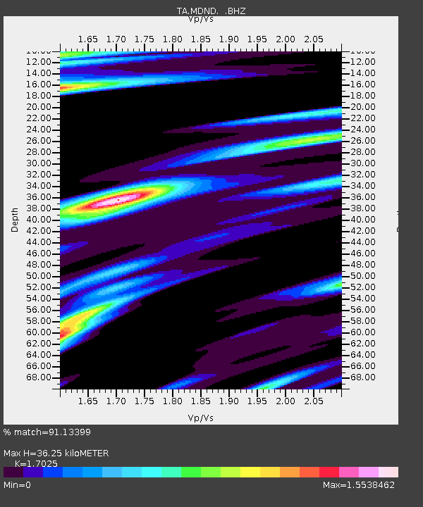
| Estimated Moho Depth: |
36.25 km |
| Estimated Crust Vp/Vs: |
1.70 |
| Assumed Crust Vp: |
6.53 km/s |
| Estimated Crust Vs: |
3.836 km/s |
| Estimated Crust Poisson's Ratio: |
0.24 |
|
| Radial Match: |
91.13399 % |
| Radial Bump: |
294 |
| Transverse Match: |
63.638268 % |
| Transverse Bump: |
392 |
| SOD ConfigId: |
506122 |
| Insert Time: |
2013-06-01 13:54:15.082 +0000 |
| GWidth: |
2.5 |
| Max Bumps: |
400 |
| Tol: |
0.001 |
|
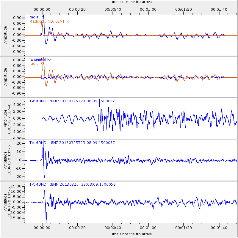
Signal To Noise
| Channel | StoN | STA | LTA |
| TA:MDND: :BHZ:20130325T23:08:09.150005Z | 55.31987 | 9.041336E-6 | 1.634374E-7 |
| TA:MDND: :BHN:20130325T23:08:09.150005Z | 7.573665 | 6.1819464E-6 | 8.162424E-7 |
| TA:MDND: :BHE:20130325T23:08:09.150005Z | 3.5133872 | 2.1971077E-6 | 6.253531E-7 |
| Arrivals |
| Ps | 4.2 SECOND |
| PpPs | 14 SECOND |
| PsPs/PpSs | 18 SECOND |


