You are here: Home > Network List > GT - Global Telemetered Seismograph Network (USAF/USGS) Stations List
> Station LBTB Lobatse, Botswana, Africa > Earthquake Result Viewer
LBTB Lobatse, Botswana, Africa - Earthquake Result Viewer
| Earthquake location: |
South Sandwich Islands Region |
| Earthquake latitude/longitude: |
-56.5/-27.5 |
| Earthquake time(UTC): |
2002/11/12 (316) 01:46:48 GMT |
| Earthquake Depth: |
120 km |
| Earthquake Magnitude: |
6.0 MB, 6.3 MW, 6.2 MW |
| Earthquake Catalog/Contributor: |
WHDF/NEIC |
|
| Network: |
GT Global Telemetered Seismograph Network (USAF/USGS) |
| Station: |
LBTB Lobatse, Botswana, Africa |
| Lat/Lon: |
25.02 S/25.60 E |
| Elevation: |
1128 m |
|
| Distance: |
49.3 deg |
| Az: |
73.112 deg |
| Baz: |
215.737 deg |
| Ray Param: |
0.068366736 |
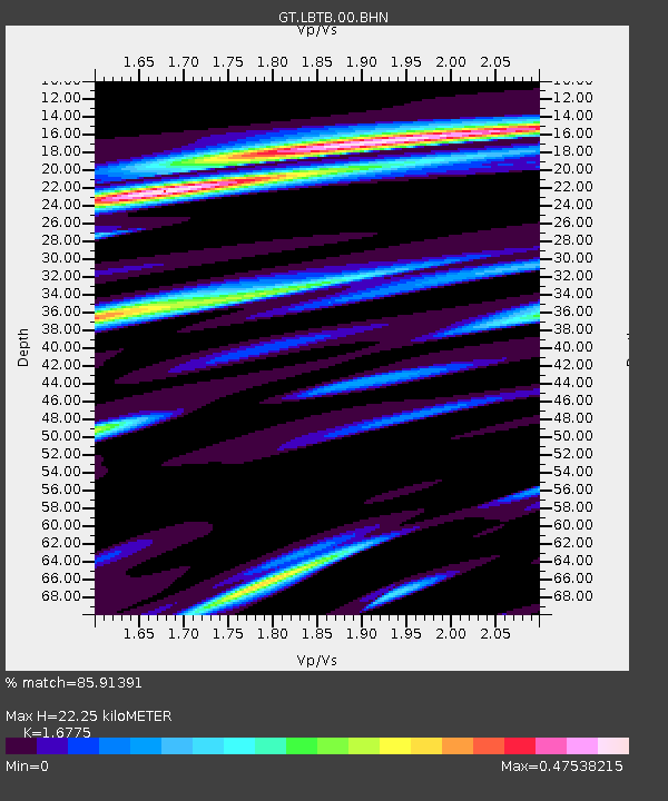
| Estimated Moho Depth: |
22.25 km |
| Estimated Crust Vp/Vs: |
1.68 |
| Assumed Crust Vp: |
6.459 km/s |
| Estimated Crust Vs: |
3.851 km/s |
| Estimated Crust Poisson's Ratio: |
0.22 |
|
| Radial Match: |
85.91391 % |
| Radial Bump: |
334 |
| Transverse Match: |
62.848045 % |
| Transverse Bump: |
400 |
| SOD ConfigId: |
4714 |
| Insert Time: |
2010-02-27 02:05:37.894 +0000 |
| GWidth: |
2.5 |
| Max Bumps: |
400 |
| Tol: |
0.001 |
|

Signal To Noise
| Channel | StoN | STA | LTA |
| GT:LBTB:00:BHN:20021112T01:54:55.475004Z | 3.5187538 | 6.057901E-7 | 1.7216041E-7 |
| GT:LBTB:00:BHE:20021112T01:54:55.475004Z | 4.2747197 | 5.508601E-7 | 1.2886461E-7 |
| GT:LBTB:00:BHZ:20021112T01:54:55.475004Z | 6.632589 | 1.4452118E-6 | 2.1789556E-7 |
| Arrivals |
| Ps | 2.5 SECOND |
| PpPs | 8.7 SECOND |
| PsPs/PpSs | 11 SECOND |


