You are here: Home > Network List > AV - Alaska Volcano Observatory Stations List
> Station MAPS Pakushin Southeast, Makushin Volcano, Alaska > Earthquake Result Viewer
MAPS Pakushin Southeast, Makushin Volcano, Alaska - Earthquake Result Viewer
*The percent match for this event was below the threshold and hence no stack was calculated.
| Earthquake location: |
Near N Coast Of New Guinea, P.N.G. |
| Earthquake latitude/longitude: |
-3.3/143.3 |
| Earthquake time(UTC): |
2014/07/08 (189) 20:09:59 GMT |
| Earthquake Depth: |
8.6 km |
| Earthquake Magnitude: |
5.1 MW, 5.5 mb, 5.2 Mwb |
| Earthquake Catalog/Contributor: |
ISC/ISC |
|
| Network: |
AV Alaska Volcano Observatory |
| Station: |
MAPS Pakushin Southeast, Makushin Volcano, Alaska |
| Lat/Lon: |
53.81 N/166.94 W |
| Elevation: |
333 m |
|
| Distance: |
70.4 deg |
| Az: |
28.742 deg |
| Baz: |
234.045 deg |
| Ray Param: |
$rayparam |
*The percent match for this event was below the threshold and hence was not used in the summary stack. |
|
| Radial Match: |
69.571785 % |
| Radial Bump: |
334 |
| Transverse Match: |
60.975697 % |
| Transverse Bump: |
352 |
| SOD ConfigId: |
3390531 |
| Insert Time: |
2019-04-12 18:42:33.239 +0000 |
| GWidth: |
2.5 |
| Max Bumps: |
400 |
| Tol: |
0.001 |
|
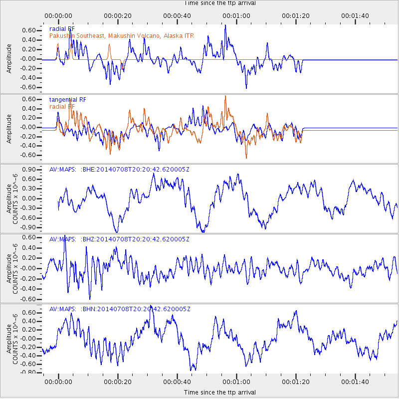
Signal To Noise
| Channel | StoN | STA | LTA |
| AV:MAPS: :BHZ:20140708T20:20:42.620005Z | 1.5055782 | 2.5304485E-7 | 1.6807154E-7 |
| AV:MAPS: :BHN:20140708T20:20:42.620005Z | 0.9971657 | 3.678424E-7 | 3.6888795E-7 |
| AV:MAPS: :BHE:20140708T20:20:42.620005Z | 1.565754 | 5.521979E-7 | 3.526722E-7 |
| Arrivals |
| Ps | |
| PpPs | |
| PsPs/PpSs | |


