You are here: Home > Network List > TA - USArray Transportable Network (new EarthScope stations) Stations List
> Station A04D Lummi Island, WA, USA > Earthquake Result Viewer
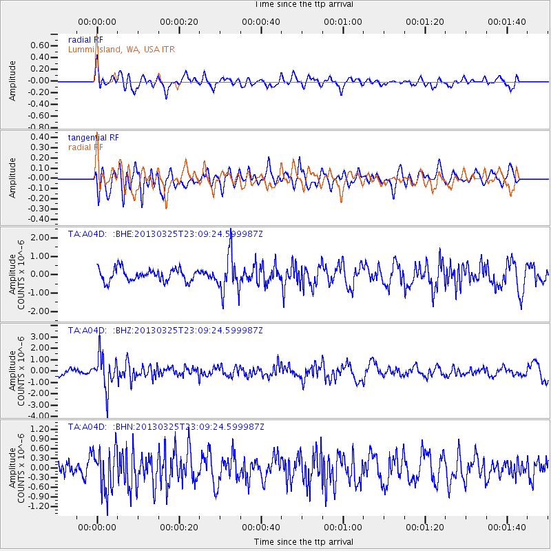
A04D Lummi Island, WA, USA - Earthquake Result Viewer
*The percent match for this event was below the threshold and hence no stack was calculated.
| Earthquake location: |
Guatemala |
| Earthquake latitude/longitude: |
14.5/-90.5 |
| Earthquake time(UTC): |
2013/03/25 (084) 23:02:12 GMT |
| Earthquake Depth: |
189 km |
| Earthquake Magnitude: |
6.2 MB, 6.2 MW, 6.2 MW |
| Earthquake Catalog/Contributor: |
WHDF/NEIC |
|
| Network: |
TA USArray Transportable Network (new EarthScope stations) |
| Station: |
A04D Lummi Island, WA, USA |
| Lat/Lon: |
48.72 N/122.71 W |
| Elevation: |
13 m |
|
| Distance: |
43.2 deg |
| Az: |
328.936 deg |
| Baz: |
131.0 deg |
| Ray Param: |
$rayparam |
*The percent match for this event was below the threshold and hence was not used in the summary stack. |
|
| Radial Match: |
60.420113 % |
| Radial Bump: |
400 |
| Transverse Match: |
63.53053 % |
| Transverse Bump: |
400 |
| SOD ConfigId: |
506122 |
| Insert Time: |
2013-06-01 13:55:46.157 +0000 |
| GWidth: |
2.5 |
| Max Bumps: |
400 |
| Tol: |
0.001 |
|
Signal To Noise
| Channel | StoN | STA | LTA |
| TA:A04D: :BHZ:20130325T23:09:24.599987Z | 6.278408 | 1.4949195E-6 | 2.3810486E-7 |
| TA:A04D: :BHN:20130325T23:09:24.599987Z | 3.0708702 | 6.421346E-7 | 2.091051E-7 |
| TA:A04D: :BHE:20130325T23:09:24.599987Z | 3.1079416 | 1.042317E-6 | 3.3537214E-7 |
| Arrivals |
| Ps | |
| PpPs | |
| PsPs/PpSs | |


