You are here: Home > Network List > TA - USArray Transportable Network (new EarthScope stations) Stations List
> Station H38A Maiden Rock, WI, USA > Earthquake Result Viewer
H38A Maiden Rock, WI, USA - Earthquake Result Viewer

| Earthquake location: |
Guatemala |
| Earthquake latitude/longitude: |
14.5/-90.5 |
| Earthquake time(UTC): |
2013/03/25 (084) 23:02:12 GMT |
| Earthquake Depth: |
189 km |
| Earthquake Magnitude: |
6.2 MB, 6.2 MW, 6.2 MW |
| Earthquake Catalog/Contributor: |
WHDF/NEIC |
|
| Network: |
TA USArray Transportable Network (new EarthScope stations) |
| Station: |
H38A Maiden Rock, WI, USA |
| Lat/Lon: |
44.68 N/92.28 W |
| Elevation: |
333 m |
|
| Distance: |
30.1 deg |
| Az: |
357.414 deg |
| Baz: |
176.488 deg |
| Ray Param: |
0.0790617 |
| Estimated Moho Depth: |
16.25 km |
| Estimated Crust Vp/Vs: |
2.10 |
| Assumed Crust Vp: |
6.571 km/s |
| Estimated Crust Vs: |
3.133 km/s |
| Estimated Crust Poisson's Ratio: |
0.35 |
|
| Radial Match: |
83.1991 % |
| Radial Bump: |
400 |
| Transverse Match: |
65.472176 % |
| Transverse Bump: |
400 |
| SOD ConfigId: |
506122 |
| Insert Time: |
2013-06-01 13:56:28.679 +0000 |
| GWidth: |
2.5 |
| Max Bumps: |
400 |
| Tol: |
0.001 |
|
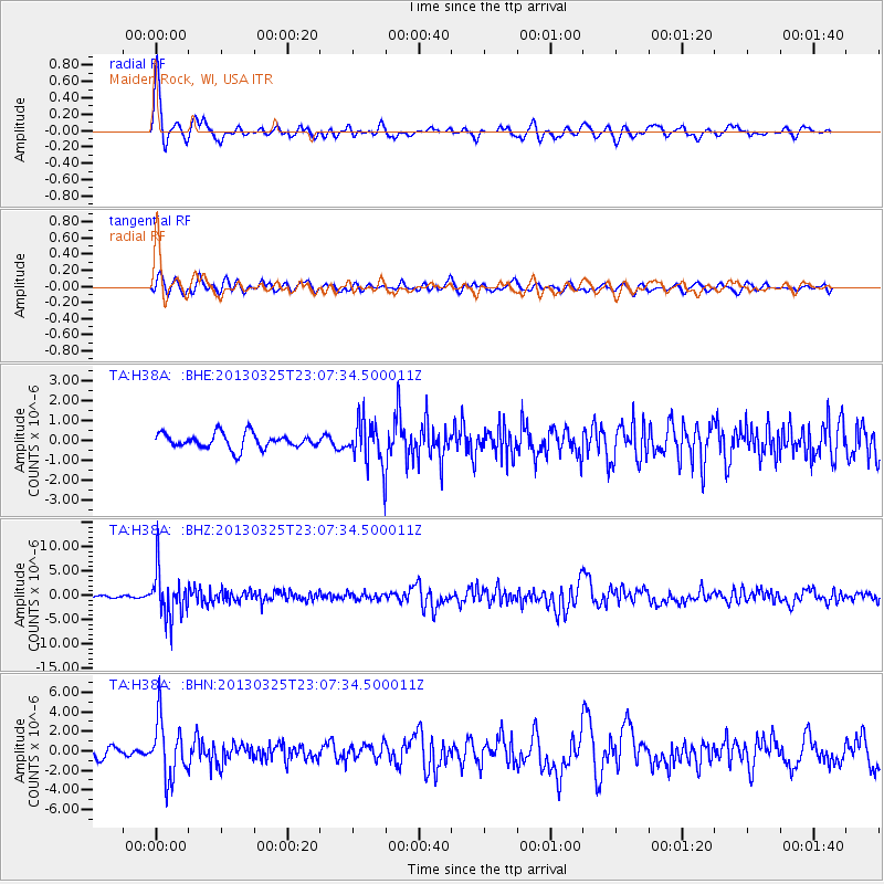
Signal To Noise
| Channel | StoN | STA | LTA |
| TA:H38A: :BHZ:20130325T23:07:34.500011Z | 20.921154 | 4.659747E-6 | 2.2272896E-7 |
| TA:H38A: :BHN:20130325T23:07:34.500011Z | 7.6056094 | 2.9630664E-6 | 3.8958962E-7 |
| TA:H38A: :BHE:20130325T23:07:34.500011Z | 2.987249 | 1.1037024E-6 | 3.6947122E-7 |
| Arrivals |
| Ps | 2.9 SECOND |
| PpPs | 7.1 SECOND |
| PsPs/PpSs | 10 SECOND |


