You are here: Home > Network List > TA - USArray Transportable Network (new EarthScope stations) Stations List
> Station F39A Loretta, WI, USA > Earthquake Result Viewer
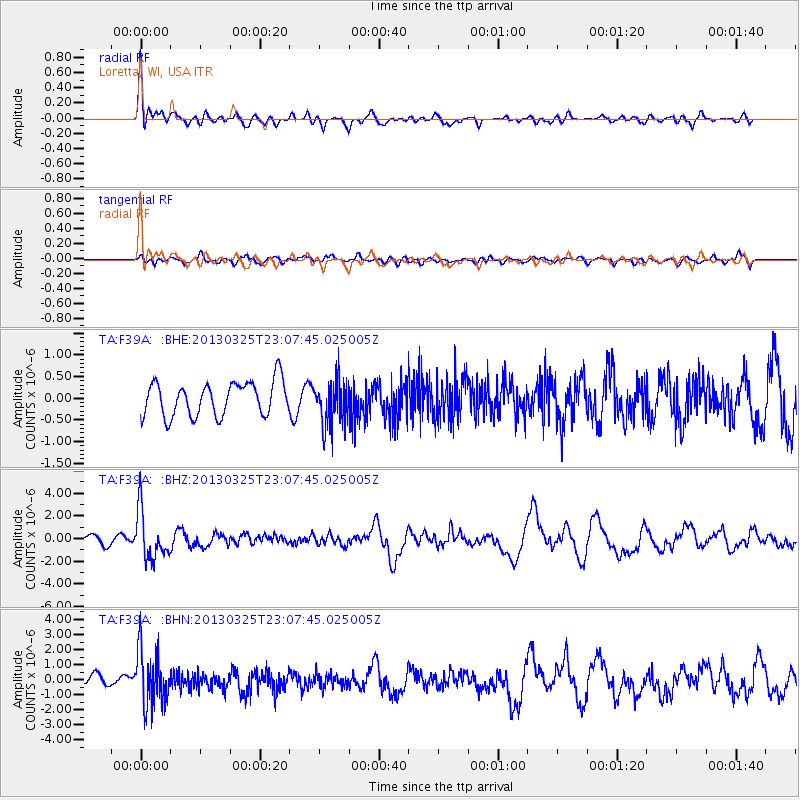
F39A Loretta, WI, USA - Earthquake Result Viewer
*The percent match for this event was below the threshold and hence no stack was calculated.
| Earthquake location: |
Guatemala |
| Earthquake latitude/longitude: |
14.5/-90.5 |
| Earthquake time(UTC): |
2013/03/25 (084) 23:02:12 GMT |
| Earthquake Depth: |
189 km |
| Earthquake Magnitude: |
6.2 MB, 6.2 MW, 6.2 MW |
| Earthquake Catalog/Contributor: |
WHDF/NEIC |
|
| Network: |
TA USArray Transportable Network (new EarthScope stations) |
| Station: |
F39A Loretta, WI, USA |
| Lat/Lon: |
45.92 N/90.92 W |
| Elevation: |
440 m |
|
| Distance: |
31.3 deg |
| Az: |
359.388 deg |
| Baz: |
179.151 deg |
| Ray Param: |
$rayparam |
*The percent match for this event was below the threshold and hence was not used in the summary stack. |
|
| Radial Match: |
69.57836 % |
| Radial Bump: |
400 |
| Transverse Match: |
61.818417 % |
| Transverse Bump: |
400 |
| SOD ConfigId: |
506122 |
| Insert Time: |
2013-06-01 13:57:13.050 +0000 |
| GWidth: |
2.5 |
| Max Bumps: |
400 |
| Tol: |
0.001 |
|
Signal To Noise
| Channel | StoN | STA | LTA |
| TA:F39A: :BHZ:20130325T23:07:45.025005Z | 4.0612526 | 2.13431E-6 | 5.2552997E-7 |
| TA:F39A: :BHN:20130325T23:07:45.025005Z | 5.587388 | 1.8408325E-6 | 3.294621E-7 |
| TA:F39A: :BHE:20130325T23:07:45.025005Z | 1.3480694 | 5.2806564E-7 | 3.9171988E-7 |
| Arrivals |
| Ps | |
| PpPs | |
| PsPs/PpSs | |


