You are here: Home > Network List > TA - USArray Transportable Network (new EarthScope stations) Stations List
> Station F45A CMU Biological Station, Beaver Island, MI, USA > Earthquake Result Viewer
F45A CMU Biological Station, Beaver Island, MI, USA - Earthquake Result Viewer
| Earthquake location: |
Guatemala |
| Earthquake latitude/longitude: |
14.5/-90.5 |
| Earthquake time(UTC): |
2013/03/25 (084) 23:02:12 GMT |
| Earthquake Depth: |
189 km |
| Earthquake Magnitude: |
6.2 MB, 6.2 MW, 6.2 MW |
| Earthquake Catalog/Contributor: |
WHDF/NEIC |
|
| Network: |
TA USArray Transportable Network (new EarthScope stations) |
| Station: |
F45A CMU Biological Station, Beaver Island, MI, USA |
| Lat/Lon: |
45.68 N/85.52 W |
| Elevation: |
173 m |
|
| Distance: |
31.4 deg |
| Az: |
6.668 deg |
| Baz: |
189.232 deg |
| Ray Param: |
0.078540154 |
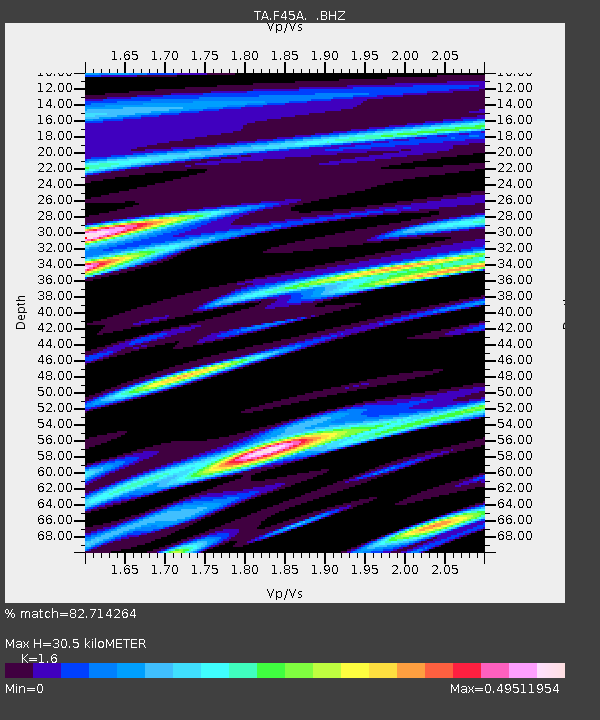
| Estimated Moho Depth: |
30.5 km |
| Estimated Crust Vp/Vs: |
1.60 |
| Assumed Crust Vp: |
6.483 km/s |
| Estimated Crust Vs: |
4.052 km/s |
| Estimated Crust Poisson's Ratio: |
0.18 |
|
| Radial Match: |
82.714264 % |
| Radial Bump: |
400 |
| Transverse Match: |
63.655636 % |
| Transverse Bump: |
400 |
| SOD ConfigId: |
506122 |
| Insert Time: |
2013-06-01 13:58:07.784 +0000 |
| GWidth: |
2.5 |
| Max Bumps: |
400 |
| Tol: |
0.001 |
|

Signal To Noise
| Channel | StoN | STA | LTA |
| TA:F45A: :BHZ:20130325T23:07:45.424999Z | 9.007032 | 4.472594E-6 | 4.965669E-7 |
| TA:F45A: :BHN:20130325T23:07:45.424999Z | 7.0270777 | 3.4755446E-6 | 4.9459317E-7 |
| TA:F45A: :BHE:20130325T23:07:45.424999Z | 2.7314925 | 1.3113137E-6 | 4.8007223E-7 |
| Arrivals |
| Ps | 3.1 SECOND |
| PpPs | 11 SECOND |
| PsPs/PpSs | 14 SECOND |


