You are here: Home > Network List > TA - USArray Transportable Network (new EarthScope stations) Stations List
> Station C40A Isle Royale National Park, MI, USA > Earthquake Result Viewer
C40A Isle Royale National Park, MI, USA - Earthquake Result Viewer
| Earthquake location: |
Guatemala |
| Earthquake latitude/longitude: |
14.5/-90.5 |
| Earthquake time(UTC): |
2013/03/25 (084) 23:02:12 GMT |
| Earthquake Depth: |
189 km |
| Earthquake Magnitude: |
6.2 MB, 6.2 MW, 6.2 MW |
| Earthquake Catalog/Contributor: |
WHDF/NEIC |
|
| Network: |
TA USArray Transportable Network (new EarthScope stations) |
| Station: |
C40A Isle Royale National Park, MI, USA |
| Lat/Lon: |
47.92 N/89.15 W |
| Elevation: |
216 m |
|
| Distance: |
33.3 deg |
| Az: |
1.605 deg |
| Baz: |
182.311 deg |
| Ray Param: |
0.0776342 |
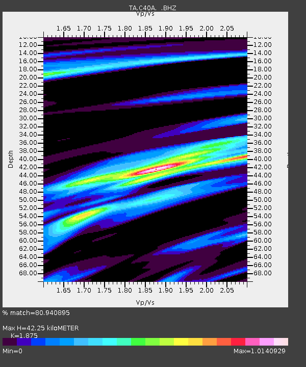
| Estimated Moho Depth: |
42.25 km |
| Estimated Crust Vp/Vs: |
1.88 |
| Assumed Crust Vp: |
6.467 km/s |
| Estimated Crust Vs: |
3.449 km/s |
| Estimated Crust Poisson's Ratio: |
0.30 |
|
| Radial Match: |
80.940895 % |
| Radial Bump: |
291 |
| Transverse Match: |
43.734016 % |
| Transverse Bump: |
350 |
| SOD ConfigId: |
506122 |
| Insert Time: |
2013-06-01 13:58:09.893 +0000 |
| GWidth: |
2.5 |
| Max Bumps: |
400 |
| Tol: |
0.001 |
|
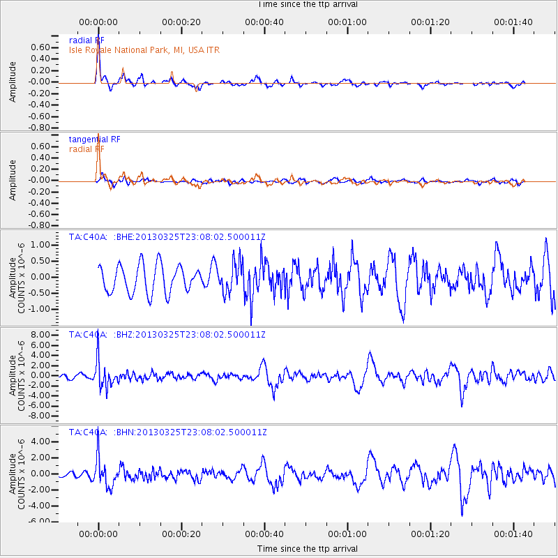
Signal To Noise
| Channel | StoN | STA | LTA |
| TA:C40A: :BHZ:20130325T23:08:02.500011Z | 8.280685 | 2.7341137E-6 | 3.3017963E-7 |
| TA:C40A: :BHN:20130325T23:08:02.500011Z | 7.3881607 | 1.8416127E-6 | 2.4926538E-7 |
| TA:C40A: :BHE:20130325T23:08:02.500011Z | 1.0957226 | 4.6505437E-7 | 4.2442713E-7 |
| Arrivals |
| Ps | 6.2 SECOND |
| PpPs | 17 SECOND |
| PsPs/PpSs | 24 SECOND |


