You are here: Home > Network List > TA - USArray Transportable Network (new EarthScope stations) Stations List
> Station O03E Paynes Creek, CA, USA > Earthquake Result Viewer
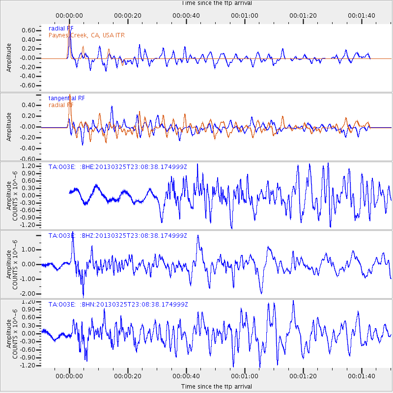
O03E Paynes Creek, CA, USA - Earthquake Result Viewer
*The percent match for this event was below the threshold and hence no stack was calculated.
| Earthquake location: |
Guatemala |
| Earthquake latitude/longitude: |
14.5/-90.5 |
| Earthquake time(UTC): |
2013/03/25 (084) 23:02:12 GMT |
| Earthquake Depth: |
189 km |
| Earthquake Magnitude: |
6.2 MB, 6.2 MW, 6.2 MW |
| Earthquake Catalog/Contributor: |
WHDF/NEIC |
|
| Network: |
TA USArray Transportable Network (new EarthScope stations) |
| Station: |
O03E Paynes Creek, CA, USA |
| Lat/Lon: |
40.29 N/121.80 W |
| Elevation: |
967 m |
|
| Distance: |
37.5 deg |
| Az: |
319.243 deg |
| Baz: |
124.233 deg |
| Ray Param: |
$rayparam |
*The percent match for this event was below the threshold and hence was not used in the summary stack. |
|
| Radial Match: |
70.98893 % |
| Radial Bump: |
400 |
| Transverse Match: |
65.59458 % |
| Transverse Bump: |
400 |
| SOD ConfigId: |
506122 |
| Insert Time: |
2013-06-01 13:59:03.604 +0000 |
| GWidth: |
2.5 |
| Max Bumps: |
400 |
| Tol: |
0.001 |
|
Signal To Noise
| Channel | StoN | STA | LTA |
| TA:O03E: :BHZ:20130325T23:08:38.174999Z | 6.2315373 | 8.8417954E-7 | 1.4188787E-7 |
| TA:O03E: :BHN:20130325T23:08:38.174999Z | 2.0841215 | 2.9101494E-7 | 1.3963435E-7 |
| TA:O03E: :BHE:20130325T23:08:38.174999Z | 2.2756593 | 4.6434442E-7 | 2.0404829E-7 |
| Arrivals |
| Ps | |
| PpPs | |
| PsPs/PpSs | |


