You are here: Home > Network List > TA - USArray Transportable Network (new EarthScope stations) Stations List
> Station E47A Iron Bridge, ON, CAN > Earthquake Result Viewer
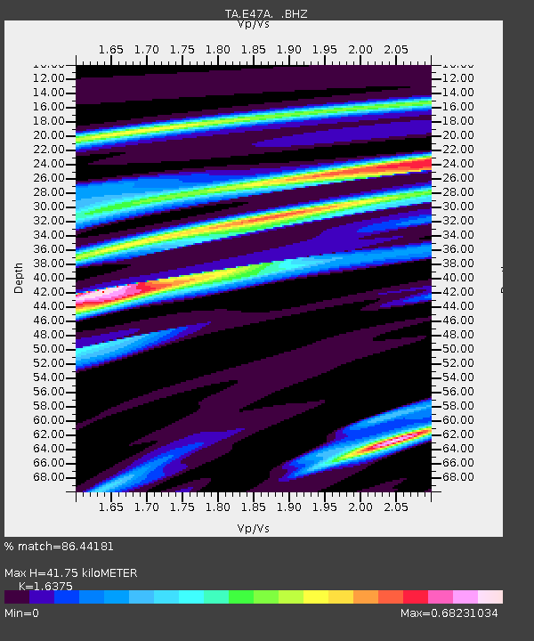
E47A Iron Bridge, ON, CAN - Earthquake Result Viewer
| Earthquake location: |
Guatemala |
| Earthquake latitude/longitude: |
14.5/-90.5 |
| Earthquake time(UTC): |
2013/03/25 (084) 23:02:12 GMT |
| Earthquake Depth: |
189 km |
| Earthquake Magnitude: |
6.2 MB, 6.2 MW, 6.2 MW |
| Earthquake Catalog/Contributor: |
WHDF/NEIC |
|
| Network: |
TA USArray Transportable Network (new EarthScope stations) |
| Station: |
E47A Iron Bridge, ON, CAN |
| Lat/Lon: |
46.45 N/83.28 W |
| Elevation: |
246 m |
|
| Distance: |
32.4 deg |
| Az: |
9.278 deg |
| Baz: |
193.055 deg |
| Ray Param: |
0.07806623 |
| Estimated Moho Depth: |
41.75 km |
| Estimated Crust Vp/Vs: |
1.64 |
| Assumed Crust Vp: |
6.467 km/s |
| Estimated Crust Vs: |
3.949 km/s |
| Estimated Crust Poisson's Ratio: |
0.20 |
|
| Radial Match: |
86.44181 % |
| Radial Bump: |
225 |
| Transverse Match: |
61.635838 % |
| Transverse Bump: |
390 |
| SOD ConfigId: |
506122 |
| Insert Time: |
2013-06-01 14:00:50.509 +0000 |
| GWidth: |
2.5 |
| Max Bumps: |
400 |
| Tol: |
0.001 |
|

Signal To Noise
| Channel | StoN | STA | LTA |
| TA:E47A: :BHZ:20130325T23:07:54.625011Z | 9.346909 | 4.0770738E-6 | 4.3619485E-7 |
| TA:E47A: :BHN:20130325T23:07:54.625011Z | 10.101433 | 2.9158307E-6 | 2.8865517E-7 |
| TA:E47A: :BHE:20130325T23:07:54.625011Z | 1.2041341 | 5.26519E-7 | 4.3725942E-7 |
| Arrivals |
| Ps | 4.5 SECOND |
| PpPs | 16 SECOND |
| PsPs/PpSs | 20 SECOND |


