You are here: Home > Network List > TA - USArray Transportable Network (new EarthScope stations) Stations List
> Station J54A Appleton, NY, USA > Earthquake Result Viewer
J54A Appleton, NY, USA - Earthquake Result Viewer
| Earthquake location: |
Guatemala |
| Earthquake latitude/longitude: |
14.5/-90.5 |
| Earthquake time(UTC): |
2013/03/25 (084) 23:02:12 GMT |
| Earthquake Depth: |
189 km |
| Earthquake Magnitude: |
6.2 MB, 6.2 MW, 6.2 MW |
| Earthquake Catalog/Contributor: |
WHDF/NEIC |
|
| Network: |
TA USArray Transportable Network (new EarthScope stations) |
| Station: |
J54A Appleton, NY, USA |
| Lat/Lon: |
43.27 N/78.64 W |
| Elevation: |
112 m |
|
| Distance: |
30.4 deg |
| Az: |
17.187 deg |
| Baz: |
203.07 deg |
| Ray Param: |
0.078937866 |
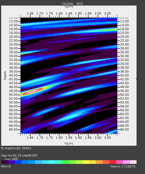
| Estimated Moho Depth: |
48.25 km |
| Estimated Crust Vp/Vs: |
1.65 |
| Assumed Crust Vp: |
6.419 km/s |
| Estimated Crust Vs: |
3.879 km/s |
| Estimated Crust Poisson's Ratio: |
0.21 |
|
| Radial Match: |
80.35503 % |
| Radial Bump: |
400 |
| Transverse Match: |
73.920616 % |
| Transverse Bump: |
400 |
| SOD ConfigId: |
506122 |
| Insert Time: |
2013-06-01 14:01:55.979 +0000 |
| GWidth: |
2.5 |
| Max Bumps: |
400 |
| Tol: |
0.001 |
|

Signal To Noise
| Channel | StoN | STA | LTA |
| TA:J54A: :BHZ:20130325T23:07:37.125011Z | 12.203558 | 5.9530494E-6 | 4.878126E-7 |
| TA:J54A: :BHN:20130325T23:07:37.125011Z | 7.429029 | 4.1209832E-6 | 5.5471355E-7 |
| TA:J54A: :BHE:20130325T23:07:37.125011Z | 4.4204903 | 1.7829075E-6 | 4.03328E-7 |
| Arrivals |
| Ps | 5.4 SECOND |
| PpPs | 18 SECOND |
| PsPs/PpSs | 24 SECOND |


